
IMAGES TAKEN NEAR TO
Lichfield Street, STONE, ST15 8NA
Introduction
This page details the photographs taken nearby to Lichfield Street, ST15 8NA by members of the Geograph project.
The Geograph project started in 2005 with the aim of publishing, organising and preserving representative images for every square kilometre of Great Britain, Ireland and the Isle of Man.

There are currently over 7.5m images from over14,400 individuals and you can help contribute to the project by visiting https://www.geograph.org.uk
Image Map
Images are licensed for reuse under creativecommons.org/licenses/by-sa/2.0
Notes
- Clicking on the map will re-center to the selected point.
- The higher the marker number, the further away the image location is from the centre of the postcode.
Image Listing (326 Images Found)
Images are licensed for reuse under creativecommons.org/licenses/by-sa/2.0
Image
Details
Distance
1

Ordnance Survey Flush Bracket S061
This can be found on the roadside wall of a building in Abbey street, Stone.
For more detail see : http://www.bench-marks.org.uk/bm20368
Image: © Peter Wood
Taken: 20 Jul 2016
0.02 miles
2
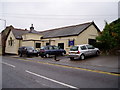
St Michael's Church Hall, Stone
A path to the right of the hall leads to the church.
Image: © Eirian Evans
Taken: 5 Aug 2008
0.03 miles
3
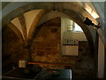
The crypt
This is the remains of the crypt from the old Priory Church - fell down 1750AD. It is now under an adjacent house and the owners kindly open it from time to time to visitors
Image: © Ian Cardinal
Taken: 8 Sep 2007
0.04 miles
4
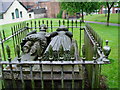
The tomb of Sir Thomas Crompton & his wife
This tomb was originally in the chancel of the Church of St Wulfad, and it remains now in the churchyard of St Michael's which replaced the former church. Sir Thomas died in 1603 and his wife in 1626.
Image: © Eirian Evans
Taken: 5 Aug 2008
0.04 miles
5
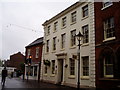
Cumberland House, Stone
On the High Street in Stone, this 18th century Georgian town house is now a surgery. It is said that the Duke of Cumberland stayed here in 1745 while his army was encamped at Stonefield.
Image: © Eirian Evans
Taken: 5 Aug 2008
0.04 miles
6
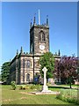
Stone War Memorial and Parish Church
The Town of Stone was named after the pile of stone raised on the graves of the Princes killed in 665AD by their father, King Wulfhere of Mercia, because of their conversion to Christianity. The Church, built over these stones in 670 AD, was replaced in 1135 AD by an Augustinian Priory, which survived until its dissolution in the reign of Henry VIII. The priory church survived as a place of worship until the building collapsed in 1749 and the present parish church dedicated to St Michael and St. Wulfad, an early example of the Gothic Revival style, was built in the 1750s using stone from the priory. The church is a Grade II* Listed Building (http://www.britishlistedbuildings.co.uk/en-385977-church-of-st-michael-stone-staffordshire British Listed Buildings)
More information at http://www.thepotteries.org/tour/003.htm Stoke-on-Trent Architecture
Image: © David Dixon
Taken: 11 Jul 2013
0.04 miles
7
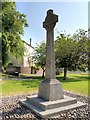
Stone War Memorial
The war memorial in the grounds of Image
Image: © David Dixon
Taken: 11 Jul 2013
0.05 miles
8
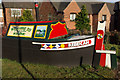
Rebekah at Stone
This curious narrowboat mock-up greets drivers heading into the town on the A520. It is an appropriate symbol; Stone has long had a close association with the Trent & Mersey Canal.
Image: © Stephen McKay
Taken: 24 Jan 2009
0.05 miles
9
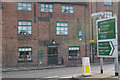
Swan Inn, Stone
This former Trent & Mersey Canal warehouse on Stafford Street was converted into a pub in 1851; it is grade II listed. Today, it is well renowned for its selection of real ales.
Image: © Stephen McKay
Taken: 24 Jan 2009
0.05 miles
10
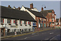
Stafford Street, Stone
This is the A520, and a part of Stone's one-way system.
Image: © Stephen McKay
Taken: 24 Jan 2009
0.05 miles