IMAGES TAKEN NEAR TO
Longton Road, STONE, ST15 8DQ
Introduction
This page details the photographs taken nearby to Longton Road, ST15 8DQ by members of the Geograph project.
The Geograph project started in 2005 with the aim of publishing, organising and preserving representative images for every square kilometre of Great Britain, Ireland and the Isle of Man.

There are currently over 7.5m images from over14,400 individuals and you can help contribute to the project by visiting https://www.geograph.org.uk
Image Map (Loading...)


Getting Data...Please wait
Leaflet Map data © OpenStreetMap
Images are licensed for reuse under creativecommons.org/licenses/by-sa/2.0
Notes
- Clicking on the map will re-center to the selected point.
- The higher the marker number, the further away the image location is from the centre of the postcode.
Image Listing (66 Images Found)
Images are licensed for reuse under creativecommons.org/licenses/by-sa/2.0
Image
Details
Distance
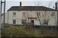
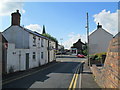
1
Longton Road, Stone
The A520 on the northern edge of Stone.
Image: © David Weston
Taken: 25 Jul 2015
0.04 miles
2
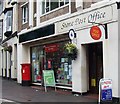
Stone Post Office
At the top of the High Street.
http://www.stonepostoffice.co.uk/
Image: © Stephen Grice
Taken: 7 Jul 2007
0.08 miles
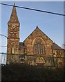
4
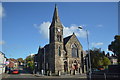
St John's Church
Former Congregational Chapel on Granville Terrace. The congregation vacated the building in 2012 after 150 years unable to find £1.75M to carry out repairs to the fabric.
Image: © John M
Taken: 27 Oct 2017
0.09 miles
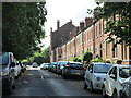
5
Radford Street, Stone
Seen from the railway bridge with Langtry's ahead.
Image: © Stephen McKay
Taken: 24 Jan 2009
0.09 miles
6
Old Road, Stone
In the middle distance is the junction with Oulton Road on the left; further on is the junction with Longton Road. The spire of St John's Church, on Longton Road, can be seen.
Image: © David Weston
Taken: 25 Jul 2015
0.09 miles
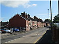
7
King's Avenue, Stone
Looking towards the junction with Radford Street. The avenue is alongside a railway line.
Image: © David Weston
Taken: 25 Jul 2015
0.12 miles
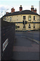
8
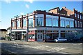
Shops on corner of Radford Road and King's Road
The ghost writing on the gable suggests that this was once the Cooperative store.
Image: © John M
Taken: 27 Oct 2017
0.13 miles
9
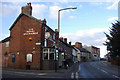
Radford Street, Stone
Looking up Radford Street at its junction with Northesk Street with the Royal Exchange pub on the left. This is the A520 towards Leek.
Image: © Stephen McKay
Taken: 24 Jan 2009
0.13 miles