IMAGES TAKEN NEAR TO
Clarke Way, STONE, ST15 0FS
Introduction
This page details the photographs taken nearby to Clarke Way, ST15 0FS by members of the Geograph project.
The Geograph project started in 2005 with the aim of publishing, organising and preserving representative images for every square kilometre of Great Britain, Ireland and the Isle of Man.

There are currently over 7.5m images from over14,400 individuals and you can help contribute to the project by visiting https://www.geograph.org.uk
Image Map (Loading...)


Getting Data...Please wait
Leaflet Map data © OpenStreetMap
Images are licensed for reuse under creativecommons.org/licenses/by-sa/2.0
Notes
- Clicking on the map will re-center to the selected point.
- The higher the marker number, the further away the image location is from the centre of the postcode.
Image Listing (11 Images Found)
Images are licensed for reuse under creativecommons.org/licenses/by-sa/2.0
Image
Details
Distance
1
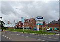
New housing development off Eccleshall Road, Stone
Image: © JThomas
Taken: 7 Sep 2019
0.08 miles
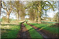
2

Track up to Walton Hill House
Image: © Derek Harper
Taken: 7 Sep 2012
0.08 miles
3
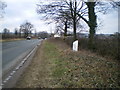
The Stone (Walton) milepost in its setting
Detailed view of the milepost in Image
Image: © Richard Law
Taken: 10 Mar 2010
0.09 miles
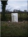
4

Old Milepost by the A520, Eccleshall Road, Stone parish
Cast iron post by the A520, in parish of STONE (STAFFORD District), Walton Heath, West of Stone, on the verge, on Southeast side of road. Lathe iron casting, erected by the County Council in the 19th/20th century.
Inscription reads:-
: NORTON BRIDGE / STATION 3 / ECCLESHALL 5 / NEWPORT 14 / MARKET - / DRAYTON (15½) : : WALTON : : STONE 1 / UTTOXETER / 14 :
Maker:-
: Chas. Lathe, Tipton. :
Staffordshire HER.
HER Number: 51346 https://www.heritagegateway.org.uk/Gateway/Results_Single.aspx?uid=MST12570&resourceID=1010
Milestone Society National ID: ST_SNEH01
Image: © J Higgins
Taken: Unknown
0.10 miles
7
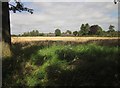
Field, Walton
From the junction of Image] with the B5026, looking across a stubble field to the edge of housing in the southwestern suburb of Stone.
Image: © Derek Harper
Taken: 7 Sep 2012
0.13 miles
8
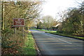
Entrance to Stone on the B5026 Eccleshall Road
Image: © Mick Malpass
Taken: 1 Dec 2011
0.17 miles
9
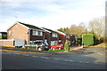
Bushberry Close, Stone
The B5026 Eccleshall Road is just behind the hedge at the end of the close.
Image: © Mick Malpass
Taken: 1 Dec 2011
0.17 miles
10
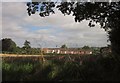
Field, Walton
Looking across the field shown in Image to houses on Longhope Drive.
Image: © Derek Harper
Taken: 7 Sep 2012
0.20 miles