IMAGES TAKEN NEAR TO
Blundell Drive, STONE, ST15 0FG
Introduction
This page details the photographs taken nearby to Blundell Drive, ST15 0FG by members of the Geograph project.
The Geograph project started in 2005 with the aim of publishing, organising and preserving representative images for every square kilometre of Great Britain, Ireland and the Isle of Man.

There are currently over 7.5m images from over14,400 individuals and you can help contribute to the project by visiting https://www.geograph.org.uk
Image Map (Loading...)


Getting Data...Please wait
Leaflet Map data © OpenStreetMap
Images are licensed for reuse under creativecommons.org/licenses/by-sa/2.0
Notes
- Clicking on the map will re-center to the selected point.
- The higher the marker number, the further away the image location is from the centre of the postcode.
Image Listing (7 Images Found)
Images are licensed for reuse under creativecommons.org/licenses/by-sa/2.0
Image
Details
Distance
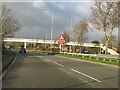
3
A34 approaching Aldi store
Stafford Road (A34). It's a new sgtore. The location point is the footbridge ahead
Image: © John Firth
Taken: 15 Jun 2013
0.12 miles
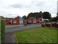
4
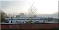
Dunoon mug factory
Originating in Scotland, the company opened this factory in 1982.
Image: © Bill Boaden
Taken: 24 Feb 2022
0.17 miles
7
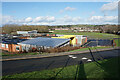
Walton Priory Middle School
A view from Beacon Rise in the direction of the centre of Stone.
Image: © Bill Boaden
Taken: 24 Feb 2022
0.23 miles