IMAGES TAKEN NEAR TO
The Fillybrooks, STONE, ST15 0DH
Introduction
This page details the photographs taken nearby to The Fillybrooks, ST15 0DH by members of the Geograph project.
The Geograph project started in 2005 with the aim of publishing, organising and preserving representative images for every square kilometre of Great Britain, Ireland and the Isle of Man.

There are currently over 7.5m images from over14,400 individuals and you can help contribute to the project by visiting https://www.geograph.org.uk
Image Map (Loading...)


Getting Data...Please wait
Leaflet Map data © OpenStreetMap
Images are licensed for reuse under creativecommons.org/licenses/by-sa/2.0
Notes
- Clicking on the map will re-center to the selected point.
- The higher the marker number, the further away the image location is from the centre of the postcode.
Image Listing (106 Images Found)
Images are licensed for reuse under creativecommons.org/licenses/by-sa/2.0
Image
Details
Distance
1
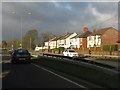
Storm clouds over Stone
Rain clouds seen from the A34 at the Walton roundabout
Image: © Peter Whatley
Taken: 7 Dec 2011
0.01 miles
2
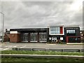
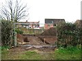
Stone Community Fire Station
A new fire station officially opened in April 2016.
Image: © Jonathan Hutchins
Taken: 17 Mar 2017
0.05 miles

4
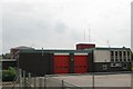
Stone fire station
Stone fire station, The Filleybrooks, Walton, Stone, Staffordshire.
Image: © Kevin Hale
Taken: 12 Jun 2006
0.06 miles
5
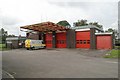
Stone fire station
Stone fire station, The Filleybrooks, Walton, Stone, Staffordshire, showing the front of the station with its large canopy. Compare this to Image which shows the rear.
Image: © Kevin Hale
Taken: 23 Oct 2006
0.06 miles
7
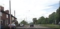
Houses along A34 approaching Whitemill Lane
Image: © John Firth
Taken: 15 Jun 2013
0.09 miles
8
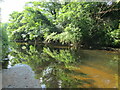
River Trent at Stone
The river near a footpath on Crown Meadow.
Image: © David Weston
Taken: 23 Jun 2021
0.10 miles
9
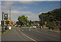
Roundabout, Stone
The Eccleshall Road, B5026, reaches the roundabout at the A34 Stone bypass. On the left is the sign for the Lamb Inn, but the pub itself is set well back from the road, and out of square.
Image: © Derek Harper
Taken: 7 Sep 2012
0.10 miles
10
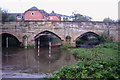
The Old Walton Bridge, Stone
This is a view of the Old Walton Bridge over the River Trent at Stone. There used to be a narrow footbridge that ran along side this single track bridge before a new bridge over the river was built. The new bridge is hidden from view in this picture.
Image: © Stephen Pearce
Taken: 20 Oct 2006
0.11 miles