IMAGES TAKEN NEAR TO
The Lindens, STONE, ST15 0BD
Introduction
This page details the photographs taken nearby to The Lindens, ST15 0BD by members of the Geograph project.
The Geograph project started in 2005 with the aim of publishing, organising and preserving representative images for every square kilometre of Great Britain, Ireland and the Isle of Man.

There are currently over 7.5m images from over14,400 individuals and you can help contribute to the project by visiting https://www.geograph.org.uk
Image Map
Images are licensed for reuse under creativecommons.org/licenses/by-sa/2.0
Notes
- Clicking on the map will re-center to the selected point.
- The higher the marker number, the further away the image location is from the centre of the postcode.
Image Listing (5 Images Found)
Images are licensed for reuse under creativecommons.org/licenses/by-sa/2.0
Image
Details
Distance

2
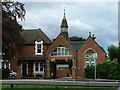
Stone Cemetery
On the junction of the A34 and A51.
Image: © Neil Lewin
Taken: 11 Aug 2006
0.13 miles
3
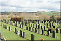
Stone Cemetery
A newer part of the cemetery which was originally opened in 1903.
Image: © Bill Boaden
Taken: 24 Feb 2022
0.15 miles
4
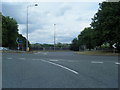
Brooms Road roundabout at A34/A51 junction
Image: © Colin Pyle
Taken: 10 Jul 2010
0.17 miles