IMAGES TAKEN NEAR TO
Broad Street, STOKE-ON-TRENT, ST1 4EJ
Introduction
This page details the photographs taken nearby to Broad Street, ST1 4EJ by members of the Geograph project.
The Geograph project started in 2005 with the aim of publishing, organising and preserving representative images for every square kilometre of Great Britain, Ireland and the Isle of Man.

There are currently over 7.5m images from over14,400 individuals and you can help contribute to the project by visiting https://www.geograph.org.uk
Image Map
Images are licensed for reuse under creativecommons.org/licenses/by-sa/2.0
Notes
- Clicking on the map will re-center to the selected point.
- The higher the marker number, the further away the image location is from the centre of the postcode.
Image Listing (159 Images Found)
Images are licensed for reuse under creativecommons.org/licenses/by-sa/2.0
Image
Details
Distance
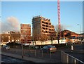
1
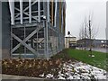
Old and new
Looking out along Broad Street to the old buildings on Cambridge Street, past the new Smithfield Car Park.
Image: © Oscar Taylor
Taken: 9 Mar 2023
0.02 miles
3
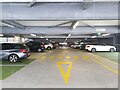
Smithfield Car Park
On Floor 1 (third storey) of Smithfield Car Park in Stoke-on-Trent. The car park opened in December 2022 and had extensive problems with puddles forming throughout the building.
The car park is laid out in a typical 'figure 8' style with ramps up to each floor. Payment is done on machines with ANPR cameras reading your numberplate as you enter and exit. To enter through one of the doors for pedestratians leading to the car park, you must enter your registration number.
As part of the council's latest phase of the Smithfield development, the car park cost £15,000,000.
Image: © Oscar Taylor
Taken: 9 Mar 2023
0.04 miles
4
The Victoria On The Square, Stoke on Trent
On Victoria Square.
Image: © JThomas
Taken: 20 Jun 2015
0.04 miles
5
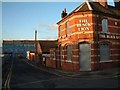
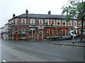
Black Lion Public House
On the corner of James Street and Broad Street, Hanley
Image: © Steven Birks
Taken: Unknown
0.05 miles
6

Crossroads of Potteries Way and Broad Street
Looking across the crossroads of Potteries Way (A5008) and Broad Street (A5006) from near to the entrance of the Smithfield Car Park.
Image: © Oscar Taylor
Taken: 9 Mar 2023
0.06 miles
7
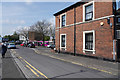
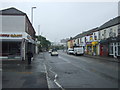
A street in Hanley
No parking here, which is a pity considering all the carparks were full.
Image: © Malcolm Neal
Taken: 30 Apr 2019
0.06 miles
8
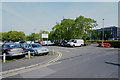
Another full carpark
All of the carparks around the Potteries Museum and Art Gallery were completely full as we attempted to visit the museum on a Tuesday morning.
Image: © Malcolm Neal
Taken: 30 Apr 2019
0.07 miles
9
Broad Street (A5006)
At the junction with the A5008.
Image: © JThomas
Taken: 20 Jun 2015
0.07 miles
10
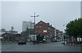
Demolition of Unity House, Hanley
Stoke City Council's 18-storey former headquarters was the 240-foot-high Unity House, built in the mid-1970s on a site previously occupied by prefab houses near Broad Street, Hanley.
Photo taken in Broad Street, just outside the Black Lion pub. http://www.geograph.org.uk/photo/343430
Unity House (the old Civic Centre) stands just off The Potteries Way
Image: © Steven Birks
Taken: Unknown
0.07 miles