IMAGES TAKEN NEAR TO
Railway View, STOKE-ON-TRENT, ST1 4BE
Introduction
This page details the photographs taken nearby to Railway View, ST1 4BE by members of the Geograph project.
The Geograph project started in 2005 with the aim of publishing, organising and preserving representative images for every square kilometre of Great Britain, Ireland and the Isle of Man.

There are currently over 7.5m images from over14,400 individuals and you can help contribute to the project by visiting https://www.geograph.org.uk
Image Map
Images are licensed for reuse under creativecommons.org/licenses/by-sa/2.0
Notes
- Clicking on the map will re-center to the selected point.
- The higher the marker number, the further away the image location is from the centre of the postcode.
Image Listing (90 Images Found)
Images are licensed for reuse under creativecommons.org/licenses/by-sa/2.0
Image
Details
Distance
1
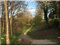
Etruria: route of the Potteries Loop Line
This footpath between Hanley and Etruria is one of the few remaining identifiable sections of the Potteries Loop Line.
Image: © Jonathan Hutchins
Taken: 20 Apr 2015
0.01 miles
2
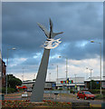
'The Pace of Recovery', Etruria
Stainless steel sculpture by Francis Gomila depicting a swan, dated 29 March 1994. Located on mini-roundabout at the junction of Festival Way and Marina Drive in the Etruria area of Stoke-on-Trent. The area formerly housed a steelworks, now redeveloped with a cinema and bowling alley. More details here: http://www.pmsa.org.uk/pmsa-database/7317/
Image: © Espresso Addict
Taken: 29 Jul 2006
0.02 miles
3
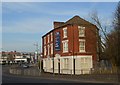
Etruria: former pub
Standing on the corner of Cobridge Road and Etruria Road, this was formerly a pub called the Rose and Crown. It is now occupied by BRB Independent Financial Advisors. More images at http://www.thepotteries.org/old_pubs/006.htm.
Image: © Jonathan Hutchins
Taken: 20 Apr 2015
0.03 miles
4

Sandon Street, Etruria
Taken on a day the wheelie-bins were in front of properties, unfortunately, but they are mostly obscured by the cars.
Image: © David Weston
Taken: 10 Jul 2015
0.03 miles
5
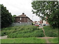
Josiah Wedgwood Street, Etruria
Seen from waste ground where there was once a railway line.
Image: © David Weston
Taken: 10 Jul 2015
0.05 miles
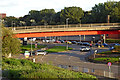
6

Etruria Flyover
The A53 north-east of Newcastle-under-Lyme passes over a roundabout here at Etruria.
Image: © David Weston
Taken: 10 Jul 2015
0.06 miles
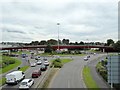
7
Road interchange in Etruria, Stoke-on-Trent
Off to the left is the slip road to join the A53 to Leek. The flyover carries the A53 across the roundabout. Ahead and to the left is the A5010 Etruria Road leading towards Hanley. Off to the right, the widened Etruria Road (A53) continues to the large interchange as it joins the A52.
All this is seen from the footbridge over Festival Way.
Image: © Roger Kidd
Taken: 11 Sep 2019
0.06 miles
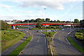
8
Festival Park: access road to/from the A53
Image: © Jonathan Hutchins
Taken: 24 Sep 2016
0.06 miles
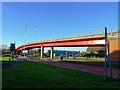
10
Etruria Road interchange in Stoke-on-Trent
Looking south-east in the evening from the Festival Way footbridge. The fly-over carries the A53 road between Stoke and Leek.
Image: © Roger Kidd
Taken: 11 Sep 2019
0.06 miles