IMAGES TAKEN NEAR TO
Stanway Close, UTTOXETER, ST14 8UZ
Introduction
This page details the photographs taken nearby to Stanway Close, ST14 8UZ by members of the Geograph project.
The Geograph project started in 2005 with the aim of publishing, organising and preserving representative images for every square kilometre of Great Britain, Ireland and the Isle of Man.

There are currently over 7.5m images from over14,400 individuals and you can help contribute to the project by visiting https://www.geograph.org.uk
Image Map (Loading...)


Getting Data...Please wait
Leaflet Map data © OpenStreetMap
Images are licensed for reuse under creativecommons.org/licenses/by-sa/2.0
Notes
- Clicking on the map will re-center to the selected point.
- The higher the marker number, the further away the image location is from the centre of the postcode.
Image Listing (15 Images Found)
Images are licensed for reuse under creativecommons.org/licenses/by-sa/2.0
Image
Details
Distance
1
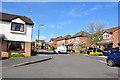
Housing Estate at Blount's Green, Uttoxeter
Image: © Mick Malpass
Taken: 14 Apr 2012
0.06 miles

3
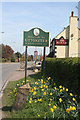
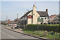
Welcome to Uttoxeter
The Plough at Blounts Green, with town sign, daffodils and a rather neglected cast iron milestone.
Image: © Alan Murray-Rust
Taken: 6 Apr 2007
0.10 miles
4
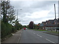
Stafford Road (A518), Blount's Green, Uttoxeter
Looking north east.
Image: © JThomas
Taken: 7 Oct 2017
0.11 miles
5
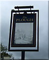
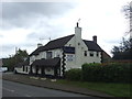
Sign for the Plough public house, Blount's Green, Uttoxeter
Image: © JThomas
Taken: 7 Oct 2017
0.11 miles

7
Welcome to Uttoxeter
The Plough at Blounts Green, with town sign, daffodils and a rather neglected cast iron milestone.
Image: © Alan Murray-Rust
Taken: 6 Apr 2007
0.12 miles
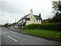
9
The Plough public house, Blount's Green, Uttoxeter
On the A518.
Image: © JThomas
Taken: 7 Oct 2017
0.12 miles
10
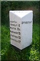
Old Milepost by the A518, Stafford Road, Uttoxeter
Cast iron post by the A518, in parish of Uttoxeter (East Staffordshire District), by Plough PH, near junction, on grass, on South side of road. Between new house 'The Ashes' and 'The Plough Inn'. Lathe iron casting, erected by the County Council in the 19th/20th century.
Inscription reads:-
: ABBOTS / BROMLEY 6 / WESTON 8¼ / HANDSACRE 12 / STAFFORD 13 / LICHFIELD 17 : : UTTOXETER : : UTTOXETER 1 :
Maker:-
: CHARLES LATHE & CO / TIPTON :
Grade II listed.
List Entry Number: 1392735 https://historicengland.org.uk/listing/the-list/list-entry/1392735
Milestone Society National ID: ST_STUT13
Image: © J Higgins
Taken: 1 Jan 2000
0.13 miles