IMAGES TAKEN NEAR TO
Avocet Close, UTTOXETER, ST14 8UG
Introduction
This page details the photographs taken nearby to Avocet Close, ST14 8UG by members of the Geograph project.
The Geograph project started in 2005 with the aim of publishing, organising and preserving representative images for every square kilometre of Great Britain, Ireland and the Isle of Man.

There are currently over 7.5m images from over14,400 individuals and you can help contribute to the project by visiting https://www.geograph.org.uk
Image Map (Loading...)


Getting Data...Please wait
Leaflet Map data © OpenStreetMap
Images are licensed for reuse under creativecommons.org/licenses/by-sa/2.0
Notes
- Clicking on the map will re-center to the selected point.
- The higher the marker number, the further away the image location is from the centre of the postcode.
Image Listing (4 Images Found)
Images are licensed for reuse under creativecommons.org/licenses/by-sa/2.0
Image
Details
Distance
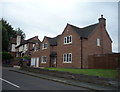
1
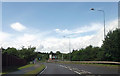
Old Knotty Way parallel to the railway
Signal box visible to right of road. Old Knotty comes from the nickname of the old North Staffordshire Railway
Image: © John Firth
Taken: 15 Jun 2013
0.16 miles
2
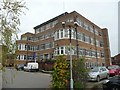
Balance Street Health Centre, Uttoxeter
The building looks fairly new, but in the style of the 60s or 70s with its flat roof and near-continuous windows.
Image: © Humphrey Bolton
Taken: 12 Nov 2009
0.23 miles
3
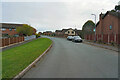
Kingfisher Way
I noticed that all the streets and roads in this estate were named after British birds. It is a fairly modern estate.
Image: © Malcolm Neal
Taken: 8 Nov 2021
0.23 miles