IMAGES TAKEN NEAR TO
Hobb Lane, UTTOXETER, ST14 8RG
Introduction
This page details the photographs taken nearby to Hobb Lane, ST14 8RG by members of the Geograph project.
The Geograph project started in 2005 with the aim of publishing, organising and preserving representative images for every square kilometre of Great Britain, Ireland and the Isle of Man.

There are currently over 7.5m images from over14,400 individuals and you can help contribute to the project by visiting https://www.geograph.org.uk
Image Map
Images are licensed for reuse under creativecommons.org/licenses/by-sa/2.0
Notes
- Clicking on the map will re-center to the selected point.
- The higher the marker number, the further away the image location is from the centre of the postcode.
Image Listing (5 Images Found)
Images are licensed for reuse under creativecommons.org/licenses/by-sa/2.0
Image
Details
Distance
1
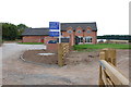
Marlpit House Farm
The photo by Patrick Mackie "Building at Marlpit House Farm" shows this as a working farm, but now the developers have moved in to produce 4 barn conversions all with 4 bedrooms. So sad another farm gone. http://www.geograph.org.uk/photo/231382
Image: © Mick Malpass
Taken: 3 Aug 2011
0.04 miles
2
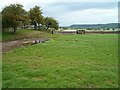
Fields at Marlpit House Farm
View west from the Staffordshire Way.
Image: © Patrick Mackie
Taken: 29 Aug 2006
0.07 miles
3
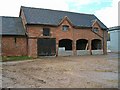
Building at Marlpit House Farm
View from the Staffordshire Way.
Image: © Patrick Mackie
Taken: 29 Aug 2006
0.07 miles
4
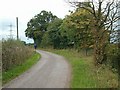
Country Lane
The Staffordshire Way follows this lane.
Image: © Patrick Mackie
Taken: 29 Aug 2006
0.16 miles
5
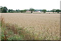
Field of Wheat
Looking over field of Wheat to the Barn Conversions at Marlpit House Farm.
Image: © Mick Malpass
Taken: 3 Aug 2011
0.19 miles