IMAGES TAKEN NEAR TO
Blythe Bridge Bank, UTTOXETER, ST14 8QW
Introduction
This page details the photographs taken nearby to Blythe Bridge Bank, ST14 8QW by members of the Geograph project.
The Geograph project started in 2005 with the aim of publishing, organising and preserving representative images for every square kilometre of Great Britain, Ireland and the Isle of Man.

There are currently over 7.5m images from over14,400 individuals and you can help contribute to the project by visiting https://www.geograph.org.uk
Image Map (Loading...)


Getting Data...Please wait
Leaflet Map data © OpenStreetMap
Images are licensed for reuse under creativecommons.org/licenses/by-sa/2.0
Notes
- Clicking on the map will re-center to the selected point.
- The higher the marker number, the further away the image location is from the centre of the postcode.
Image Listing (2 Images Found)
Images are licensed for reuse under creativecommons.org/licenses/by-sa/2.0
Image
Details
Distance
1
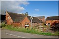
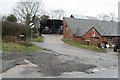
Derelict Farm on the Entrance to Potts Lane
In March 2007 when Alan Murray-Rust took a similar photo, this farm was in full swing, but sadly, it now looks as if it has been abandoned.
http://www.geograph.org.uk/photo/354367
Image: © Mick Malpass
Taken: 30 Oct 2011
0.23 miles