IMAGES TAKEN NEAR TO
Highwood, UTTOXETER, ST14 8PS
Introduction
This page details the photographs taken nearby to ST14 8PS by members of the Geograph project.
The Geograph project started in 2005 with the aim of publishing, organising and preserving representative images for every square kilometre of Great Britain, Ireland and the Isle of Man.

There are currently over 7.5m images from over14,400 individuals and you can help contribute to the project by visiting https://www.geograph.org.uk
Image Map
Images are licensed for reuse under creativecommons.org/licenses/by-sa/2.0
Notes
- Clicking on the map will re-center to the selected point.
- The higher the marker number, the further away the image location is from the centre of the postcode.
Image Listing (4 Images Found)
Images are licensed for reuse under creativecommons.org/licenses/by-sa/2.0
Image
Details
Distance
1
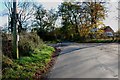
Country Crossroads near Woodcrofts Farm
Image: © Mick Malpass
Taken: 6 Nov 2011
0.03 miles
2
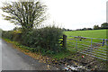
A slightly muddy field entrance
A field of grass which is empty of stock.
Image: © Malcolm Neal
Taken: 8 Nov 2021
0.11 miles
4
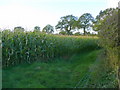
Crop of maize
Looking to the west of the road from Wrenpark to Gorsty Hill.
Image: © Jonathan Billinger
Taken: 21 Oct 2008
0.25 miles