IMAGES TAKEN NEAR TO
Hodge Lane, UTTOXETER, ST14 8PE
Introduction
This page details the photographs taken nearby to Hodge Lane, ST14 8PE by members of the Geograph project.
The Geograph project started in 2005 with the aim of publishing, organising and preserving representative images for every square kilometre of Great Britain, Ireland and the Isle of Man.

There are currently over 7.5m images from over14,400 individuals and you can help contribute to the project by visiting https://www.geograph.org.uk
Image Map
Images are licensed for reuse under creativecommons.org/licenses/by-sa/2.0
Notes
- Clicking on the map will re-center to the selected point.
- The higher the marker number, the further away the image location is from the centre of the postcode.
Image Listing (8 Images Found)
Images are licensed for reuse under creativecommons.org/licenses/by-sa/2.0
Image
Details
Distance
1
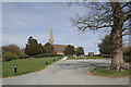
St John's Church at Smithy Hill
It is not clear which of the surrounding hamlets this isolated church belongs to! It is simply signed as St John's Church at the junction of Hodge Lane with the B5017 at Birch Cross.
Later addition - April 2008: Further information now indicates that this church is St.John's, Marchington Woodlands. It was built in 1858 at the instigation of the owner of the adjacent Smallwood Manor because of the distance to either of the nearest existing churches. After the Manor became a school, the church served effectively for many decades as the school chapel until a new school chapel was built. The parish is now closely linked to the parish of Marchington itself.
Image: © Alan Murray-Rust
Taken: 6 Apr 2007
0.20 miles
2
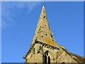
St. John's church, Marchington Woodlands; spire
Some intricate Victorian detail to be seen up above.
Image: © Jonathan Billinger
Taken: 21 Oct 2008
0.21 miles
3
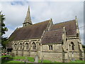
The Church of St John at Smithy Hill
Viewed from the south-east.
Image: © Peter Wood
Taken: 18 Jul 2016
0.22 miles
4
St John's church at Smithy Hill, from Gorsty Hill
For the view in the opposite direction, see Image
Image: © Christine Johnstone
Taken: 25 Jul 2018
0.22 miles
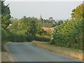
5
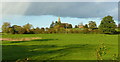
St. John's church from Twenty Acres
Looking across East Staffordshire pasture land on a golden October afternoon.
Image: © Jonathan Billinger
Taken: 21 Oct 2008
0.22 miles
6
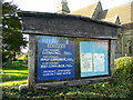
St. John's church, Marchington Woodlands; notice board
Note it declares "The Parish of..." not "The church of...".
Image: © Jonathan Billinger
Taken: 21 Oct 2008
0.22 miles
7
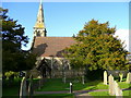
St. John's church, Marchington Woodlands
Looking from the south. See Image for an account of the church's history.
Image: © Jonathan Billinger
Taken: 21 Oct 2008
0.22 miles
8
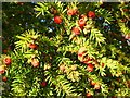
Fruit of the yew
Taxus baccata in St. John's churchyard.
The seed cones are highly modified, each cone containing a single seed 4–7 millimetres (0.16–0.28 in) long partly surrounded by a modified scale which develops into a soft, bright red berry-like structure called an aril, 8–15 millimetres (0.31–0.59 in) long and wide and open at the end. The arils are mature 6-9 months after pollination, and with the seed contained are eaten by thrushes, waxwings and other birds, which disperse the hard seeds undamaged in their droppings; maturation of the arils is spread over 2-3 months, increasing the chances of successful seed dispersal. The seed itself is extremely poisonous and bitter. The aril is not poisonous, and is gelatinous and very sweet tasting.
Ref Wiki.
Image: © Jonathan Billinger
Taken: 21 Oct 2008
0.22 miles