IMAGES TAKEN NEAR TO
Marchington Cliff, UTTOXETER, ST14 8ND
Introduction
This page details the photographs taken nearby to ST14 8ND by members of the Geograph project.
The Geograph project started in 2005 with the aim of publishing, organising and preserving representative images for every square kilometre of Great Britain, Ireland and the Isle of Man.

There are currently over 7.5m images from over14,400 individuals and you can help contribute to the project by visiting https://www.geograph.org.uk
Image Map (Loading...)


Getting Data...Please wait
Leaflet Map data © OpenStreetMap
Images are licensed for reuse under creativecommons.org/licenses/by-sa/2.0
Notes
- Clicking on the map will re-center to the selected point.
- The higher the marker number, the further away the image location is from the centre of the postcode.
Image Listing (6 Images Found)
Images are licensed for reuse under creativecommons.org/licenses/by-sa/2.0
Image
Details
Distance
1
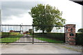
Driveway and Gates to Swilcarlawn Farm
Image: © Mick Malpass
Taken: 20 Oct 2011
0.08 miles
3
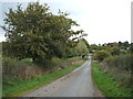
Country lane near Swilcarlawn Farm
Looking north east.
Image: © JThomas
Taken: 7 Oct 2017
0.13 miles
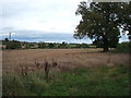
4
Cottage at Swilcar Lawn
Immediately behind the house, the steep wooded slopes of Marchington Cliff drop down to the valley of the River Dove
Image: © Oliver Dixon
Taken: 5 Jul 2006
0.19 miles
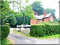
5
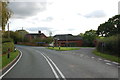
Road Junction in front of Sowley Cottage Farm
Hoar Cross to the right, Newborough and Burton to the left, Uttoxeter to the rear.
Image: © Mick Malpass
Taken: 20 Oct 2011
0.22 miles
6
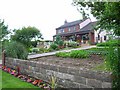
Sowley, Forest Road
Why do most people put their kitchen garden (if any) hidden round the back of the house? A good kitchen garden like this one deserves better. This one can be seen from Forest Road which traverses the northern end of Needwood Forest.
Image: © Oliver Dixon
Taken: 5 Jul 2006
0.23 miles