IMAGES TAKEN NEAR TO
Jacks Lane, UTTOXETER, ST14 8LW
Introduction
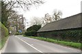
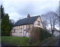
This page details the photographs taken nearby to Jacks Lane, ST14 8LW by members of the Geograph project.
The Geograph project started in 2005 with the aim of publishing, organising and preserving representative images for every square kilometre of Great Britain, Ireland and the Isle of Man.

There are currently over 7.5m images from over14,400 individuals and you can help contribute to the project by visiting https://www.geograph.org.uk
Image Map
Images are licensed for reuse under creativecommons.org/licenses/by-sa/2.0
Notes
- Clicking on the map will re-center to the selected point.
- The higher the marker number, the further away the image location is from the centre of the postcode.
Image Listing (7 Images Found)
Images are licensed for reuse under creativecommons.org/licenses/by-sa/2.0
Image
Details
Distance
3
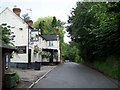
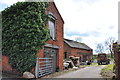
Entrance to Bag Lane, Marchington
This lane leaves the high street, after a few hundred yards it turns sharp left and joins the B5017 on the outskirts of the village. The Bulls Head is located on this lane.http://www.bullsheadmarchington.co.uk/index.htm
Image: © Mick Malpass
Taken: 6 Nov 2011
0.15 miles

6
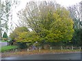
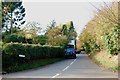
Green Lane, Marchington
This narrow lane ends at a triangular island with a tree with many thin branches radiating from the crown.
Image: © Humphrey Bolton
Taken: 12 Nov 2009
0.25 miles