IMAGES TAKEN NEAR TO
Hound Hill, UTTOXETER, ST14 8LN
Introduction
This page details the photographs taken nearby to Hound Hill, ST14 8LN by members of the Geograph project.
The Geograph project started in 2005 with the aim of publishing, organising and preserving representative images for every square kilometre of Great Britain, Ireland and the Isle of Man.

There are currently over 7.5m images from over14,400 individuals and you can help contribute to the project by visiting https://www.geograph.org.uk
Image Map
Images are licensed for reuse under creativecommons.org/licenses/by-sa/2.0
Notes
- Clicking on the map will re-center to the selected point.
- The higher the marker number, the further away the image location is from the centre of the postcode.
Image Listing (10 Images Found)
Images are licensed for reuse under creativecommons.org/licenses/by-sa/2.0
Image
Details
Distance
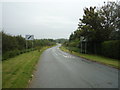
5

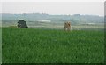
Field Edge at Hound Hill
Looking north-eastward.
Image: © Peter Wood
Taken: 18 Jul 2016
0.16 miles
7
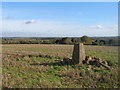
Hound Hill
A small wheat covered hill above Marchington with a triangulation station.
Image: © Richard Webb
Taken: 1 May 2004
0.17 miles
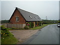
8
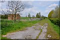
Farm access track with straw bales and cattle crush
This track runs alongside the Dovegate Prison, which is behind the hedge on the right.
Image: © Mick Malpass
Taken: 6 May 2012
0.17 miles
9
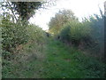
Track towards the road east of Hound Hill
Image: © John Slater
Taken: 25 Oct 2017
0.23 miles
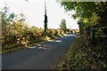
10
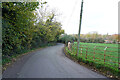
Getting close to Marchington
This minor road is narrow and very twisty, with few passing places.
Image: © Malcolm Neal
Taken: 8 Nov 2021
0.25 miles