IMAGES TAKEN NEAR TO
Coronation Crescent, UTTOXETER, ST14 5LD
Introduction
This page details the photographs taken nearby to Coronation Crescent, ST14 5LD by members of the Geograph project.
The Geograph project started in 2005 with the aim of publishing, organising and preserving representative images for every square kilometre of Great Britain, Ireland and the Isle of Man.

There are currently over 7.5m images from over14,400 individuals and you can help contribute to the project by visiting https://www.geograph.org.uk
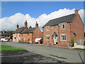
Image Map
Images are licensed for reuse under creativecommons.org/licenses/by-sa/2.0
Notes
- Clicking on the map will re-center to the selected point.
- The higher the marker number, the further away the image location is from the centre of the postcode.
Image Listing (65 Images Found)
Images are licensed for reuse under creativecommons.org/licenses/by-sa/2.0
Image
Details
Distance
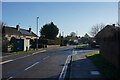
1

Northfield Avenue
Looking along Northfield Avenue towards Woodseat Grove. The morning is still cloudless making a very nice change from all the fog of recent times.
Image: © Malcolm Neal
Taken: 17 Jan 2022
0.06 miles
2
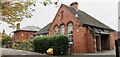
The Dove First School and Chalice House
Image: © Chris Morgan
Taken: 19 Oct 2020
0.08 miles
3
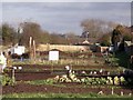
New allotments
During 2012, the Rocester Allotments Association established these new allotments on the former track bed of the Ashbourne Branch of the North Staffordshire Railway.
Image: © Ian Calderwood
Taken: 16 Feb 2013
0.09 miles
4
Ashbourne Road
Now entering the village of Rocester. This village has the huge JCB world Headquarters to the west of it.
Image: © Malcolm Neal
Taken: 17 Jan 2022
0.11 miles
5
Church Lane, Rocester
Off Ashbourne Road.
Image: © Richard Vince
Taken: 20 Aug 2022
0.11 miles
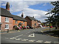
6
Church Lane, Rocester
Looking towards the junction with Ashbourne Road. The house on the corner (with the tall chimneys) is called "The Former Queens Arms".
Image: © David Weston
Taken: 28 Sep 2017
0.12 miles
7
Churchyard cross at the Church of St Michael
Grade II* listed dating from the 13th century
Image: © Graham Hogg
Taken: 19 Oct 2020
0.12 miles
8
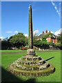
Cross in Rocester churchyard
A medieval cross, thought to be 13th-century, a short distance north of St Michael's Church. Little remains of the cross-head. It is Grade II* listed.
Image: © David Weston
Taken: 28 Sep 2017
0.12 miles
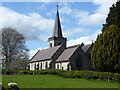
10
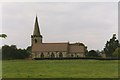
Rocester Church
St Michael's Church has 13C features but was much rebuilt in 1870-2, including the addition of a spire to the tower. There is a well-preserved churchyard cross.
Image: © Humphrey Bolton
Taken: 6 Jul 1999
0.13 miles