IMAGES TAKEN NEAR TO
Lady Meadow Close, UTTOXETER, ST14 5EY
Introduction
This page details the photographs taken nearby to Lady Meadow Close, ST14 5EY by members of the Geograph project.
The Geograph project started in 2005 with the aim of publishing, organising and preserving representative images for every square kilometre of Great Britain, Ireland and the Isle of Man.

There are currently over 7.5m images from over14,400 individuals and you can help contribute to the project by visiting https://www.geograph.org.uk
Image Map
Images are licensed for reuse under creativecommons.org/licenses/by-sa/2.0
Notes
- Clicking on the map will re-center to the selected point.
- The higher the marker number, the further away the image location is from the centre of the postcode.
Image Listing (25 Images Found)
Images are licensed for reuse under creativecommons.org/licenses/by-sa/2.0
Image
Details
Distance
1
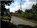
Oak Road, Denstone
Near the southern edge of the village.
Image: © Richard Vince
Taken: 20 Aug 2022
0.11 miles
2
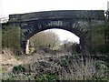
North Staffordshire Railway Bridge
The N.S.R. or "Knotty" opened in 1849 and lasted into B.R. days. This section of the line closed in 1965 and this bridge is an isolated relic, between the houses of Denstone and the J.C.B. world headquarters.
Image: © Ian Calderwood
Taken: 21 Mar 2009
0.14 miles
3
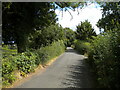
Lady Meadow Lane south of Denstone
Heading towards Rocester.
Image: © Richard Vince
Taken: 20 Aug 2022
0.14 miles
6
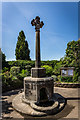
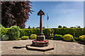
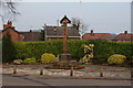
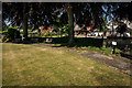
Denstone Village cross and drinking fountain
The village cross and drinking fountain are in stone. They are on two steps, and have an octagonal pedestal with an inscription, containing a spring in a recess with a shaped head and a semicircular projecting trough. On the pedestal is an octagonal base carrying an octagonal shaft and a foliated cross.
https://historicengland.org.uk/listing/the-list/list-entry/1278526
Image: © Brian Deegan
Taken: 28 May 2020
0.16 miles
7
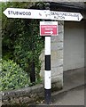
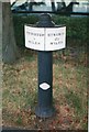
Old Direction Sign - Signpost by College Road
Ball finial - 2 arms; Staffs ball by the UC road, in parish of Denstone (East Staffordshire District), at eastern end of College Road at roundabout by bus shelter.
Surveyed
Milestone Society National ID: ST_SK1040
Image: © Milestone Society
Taken: Unknown
0.16 miles
8
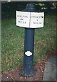
Old Caldon Canal milemarker now by Denstone bowling green
Milemarker from the Caldon Canal, Uttoxeter Branch, in parish of Denstone (East Staffordshire District); was by Uttoxeter Canal, is now alongside the bowling green in Denstone. See also nearby: UTT-05 https://www.geograph.org.uk/photo/6095601
Inscription reads:-
: ETRURIA / 24 / MILES : : UTTOXETER / 6 / MILES :
Maker:-
: R&D / STONE / 1820 :
Surveyed
Milestone Society National ID: UTT-06
Image: © Milestone Society
Taken: Unknown
0.17 miles
9
Old Caldon Canal milemarker now by Denstone bowling green
Milemarker from the Caldon Canal, Uttoxeter Branch, in parish of Denstone (East Staffordshire District); was by Uttoxeter Canal, is now alongside the bowling green in Denstone. See also nearby: UTT-06 https://www.geograph.org.uk/photo/6095592
Inscription reads:-
: UTTOXETER / 5 / MILES : : ETRURIA / 25 / MILES :
Maker:-
: R&D / STONE / 1820 :
Surveyed
Milestone Society National ID: UTT-05
Image: © Milestone Society
Taken: Unknown
0.17 miles
10
Two Mile Markers, Denstone Bowling Green
Both are Original 1820 mile markers from the now removed Uttoxeter Branch. Not in their correct positions :)
Left :-
Mile Marker 24-6
Milestone Society National ID: UTT-06
Right :-
Mile Marker 25-5
Milestone Society National ID: UTT-05
Image: © Brian Deegan
Taken: 28 May 2020
0.17 miles