IMAGES TAKEN NEAR TO
Franklyn Street, STOKE-ON-TRENT, ST1 3HD
Introduction
This page details the photographs taken nearby to Franklyn Street, ST1 3HD by members of the Geograph project.
The Geograph project started in 2005 with the aim of publishing, organising and preserving representative images for every square kilometre of Great Britain, Ireland and the Isle of Man.

There are currently over 7.5m images from over14,400 individuals and you can help contribute to the project by visiting https://www.geograph.org.uk
Image Map (Loading...)


Getting Data...Please wait
Leaflet Map data © OpenStreetMap
Images are licensed for reuse under creativecommons.org/licenses/by-sa/2.0
Notes
- Clicking on the map will re-center to the selected point.
- The higher the marker number, the further away the image location is from the centre of the postcode.
Image Listing (128 Images Found)
Images are licensed for reuse under creativecommons.org/licenses/by-sa/2.0
Image
Details
Distance
3
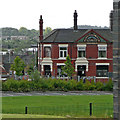
George and Dragon near Joiner's Square, Stoke-on-Trent
This is a chance snap of a superb example of a Victorian red-brick public house taken with telephot assistance from a distance of nearly 150 metres on the Caldon Canal. Parkers brewery pubs featured fine terra-cotta and tiling decoration.
Image: © Roger Kidd
Taken: 4 Sep 2009
0.06 miles
4
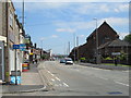
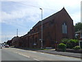
Leek Road at Joiner's Square
The main road (the A52) running north-east of the town of Stoke-upon-Trent. On the left, near the junction in the foreground, the sign for the Village Tavern pub can be seen. On the right is All Saints Church.
Image: © David Weston
Taken: 10 Jun 2015
0.06 miles
7
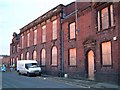
Johnson Brothers Sanitary Ware Factory
On Eastwood Road, Hanley - the inscription on the top reads "Johnson Brothers (Hanley) Ltd Sanitary Works Erected 1896" - this factory was called the Trent Works.
The pottery behind has been demolished for housing - the offices shown in the photo have been retained to be incorporated in the development.
See photo of the demolition:- http://www.geograph.org.uk/photo/330942
See more on Johnson Brothers:- http://www.thepotteries.org/allpotters/607.htm
Image: © Steven Birks
Taken: Unknown
0.09 miles
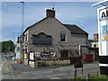
8
The Village Tavern, Joiner's Square
A pub on Leek Road, south-east of Hanley.
Image: © David Weston
Taken: 10 Jun 2015
0.10 miles
9
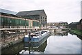
Potteries boats, Caldon Canal
The Caldon Canal saw some of the last commercial narrowboat traffic in the Midlands. The boats moored here were used to move pottery between different factory sites along the Caldon Canal. Boats can also be seen moored on the other bank in the distance at Image
Image: © David Stowell
Taken: Unknown
0.11 miles
10
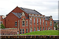
Johnson Brothers (Hanley) Limited Sanitary Works
This is the former Johnson Brothers (Hanley) Limited Sanitary Works, erected in 1896 in Eastwood Road north of Joiner's Square in Stoke-on-Trent. It has been retained and fitted out as apartments. The factory behind it has been demolished and the land redeveloped with housing.
This is a telephoto assisted image, taken from a passing narrowboat on the Caldon Canal south of Bridge No 9. https://www.geograph.org.uk/photo/343831
Image: © Roger Kidd
Taken: 12 Sep 2019
0.11 miles