IMAGES TAKEN NEAR TO
Bluestones Close, LEEK, ST13 8TD
Introduction
This page details the photographs taken nearby to Bluestones Close, ST13 8TD by members of the Geograph project.
The Geograph project started in 2005 with the aim of publishing, organising and preserving representative images for every square kilometre of Great Britain, Ireland and the Isle of Man.

There are currently over 7.5m images from over14,400 individuals and you can help contribute to the project by visiting https://www.geograph.org.uk
Image Map
Images are licensed for reuse under creativecommons.org/licenses/by-sa/2.0
Notes
- Clicking on the map will re-center to the selected point.
- The higher the marker number, the further away the image location is from the centre of the postcode.
Image Listing (21 Images Found)
Images are licensed for reuse under creativecommons.org/licenses/by-sa/2.0
Image
Details
Distance
1
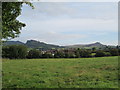
Blackshaw Moor and the Roaches
Viewed from the road to Thorncliffe: across the field are houses of the Tittesworth Estate; in the distance are the Roaches on the left, and Ramshaw Rocks on the right.
Image: © David Weston
Taken: 24 Aug 2014
0.08 miles
2
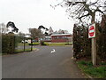
Exit from Blackshaw Moor Primary School
Image: © Eirian Evans
Taken: 20 Apr 2021
0.09 miles
4
Roman Road
A length of characteristically straight Roman Road crosses Blackshaw Moor
It continues to the right of the Ramshaw Rocks seen here in the distance
Image: © Bob Harvey
Taken: 17 Jul 2014
0.11 miles
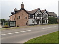
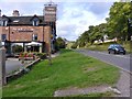
5
The Three Horseshoes Inn, Blackshaw Moor
Image: © David Smith
Taken: 1 Sep 2017
0.12 miles
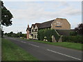
6
The Three Horseshoes at Blackshaw Moor
Image: © Eirian Evans
Taken: 20 Apr 2021
0.12 miles
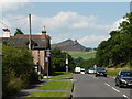
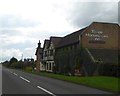
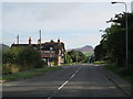
7
Three Horseshoes Inn, Blackshaw Moor
A landmark roadside inn on the A53 between Leek and Buxton
Image: © Richard Law
Taken: 17 Mar 2010
0.12 miles
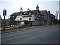
8
The Three Horseshoes, Blackshaw Moor
An inn on the A53 near Leek.
Image: © David Weston
Taken: 24 Aug 2014
0.12 miles
9
The Three Horseshoes, Blackshaw Moor
Looking north-east along the A53, from Leek to Buxton. On the left is the Three Horseshoes Inn; straight ahead are the Ramshaw Rocks.
The road is shown on the map as a Roman road; however, the description of Leek in British History Online - http://www.british-history.ac.uk/report.aspx?compid=22911 - says that the road was laid out in the 1760s (and that the course of the Roman road between Leek and Buxton is unknown). Whenever it was built, it seems that the surveyor used a peak on Ramshaw Rocks as a guide for this section.
Image: © David Weston
Taken: 24 Aug 2014
0.12 miles
10
Three Horseshoes
The Three Horseshoes Inn on the A53 in Staffordshire.
Image: © Gordon Griffiths
Taken: 13 Sep 2018
0.12 miles