IMAGES TAKEN NEAR TO
Meerbrook, LEEK, ST13 8SW
Introduction
This page details the photographs taken nearby to ST13 8SW by members of the Geograph project.
The Geograph project started in 2005 with the aim of publishing, organising and preserving representative images for every square kilometre of Great Britain, Ireland and the Isle of Man.

There are currently over 7.5m images from over14,400 individuals and you can help contribute to the project by visiting https://www.geograph.org.uk
Image Map
Images are licensed for reuse under creativecommons.org/licenses/by-sa/2.0
Notes
- Clicking on the map will re-center to the selected point.
- The higher the marker number, the further away the image location is from the centre of the postcode.
Image Listing (34 Images Found)
Images are licensed for reuse under creativecommons.org/licenses/by-sa/2.0
Image
Details
Distance
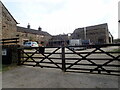
1
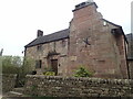
Middle Hulme Farm
C17th farmhouse with later additions, which is listed grade II.
Image: © Eirian Evans
Taken: 20 Apr 2021
0.01 miles
4
Middle Hulme Farm seen from Whitty Lane
Image: © Neil Theasby
Taken: 22 Jun 2021
0.02 miles
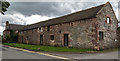
7
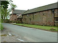
Middle Hulme
Old Farm Buildings made from local stone
Image: © Peter Hodge
Taken: 27 May 2006
0.04 miles
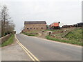
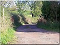
8
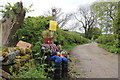
Entrance and guardian - Whitty Lane(?)
Staffs Moorlands/Churnet Way junction which soon loses its superior surface. Whitty Lane is questioned above as at a 90deg bend the right of way heads over a field to an unmarked footbridge over a gully full of rocks and roots Image which continues on the marked route to Upper Hulme, but it must have been a long time since it was a track/lane. If ever?
Image: © Peter Turner
Taken: 21 May 2016
0.04 miles
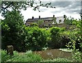
9
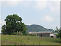
Middle Hulme farm
Seen from the Tittesworth nature reserve.
Image: © Stephen Craven
Taken: 23 Jun 2014
0.04 miles
10
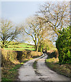
Whitty Lane
Whitty Lane as it leaves a minor road beside the farm at Middle Hulme heading towards the small settlement at Upper Hulme. It's a public footpath and is the route of the Churnet Way.
Image: © Trevor Littlewood
Taken: 24 Dec 2019
0.05 miles