IMAGES TAKEN NEAR TO
Pot Hooks Lane, LEEK, ST13 7TA
Introduction
This page details the photographs taken nearby to Pot Hooks Lane, ST13 7TA by members of the Geograph project.
The Geograph project started in 2005 with the aim of publishing, organising and preserving representative images for every square kilometre of Great Britain, Ireland and the Isle of Man.

There are currently over 7.5m images from over14,400 individuals and you can help contribute to the project by visiting https://www.geograph.org.uk
Image Map
Images are licensed for reuse under creativecommons.org/licenses/by-sa/2.0
Notes
- Clicking on the map will re-center to the selected point.
- The higher the marker number, the further away the image location is from the centre of the postcode.
Image Listing (23 Images Found)
Images are licensed for reuse under creativecommons.org/licenses/by-sa/2.0
Image
Details
Distance
2
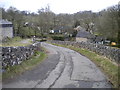
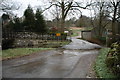
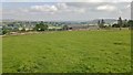
Descending into Butterton
The southern approach to Butterton is a steep descent into the Hoo Brook valley, past various farm buildings. The greater part of the village is north of the brook.
Image: © Richard Vince
Taken: 23 Feb 2013
0.07 miles
3
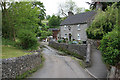
Butterton Village Ford
The Hoo Brook flows across the road.
Image: © Nigel Freeman
Taken: 19 Mar 2006
0.07 miles
5
Butterton Ford in the Ice
This is a second part of the ford at Butterton which runs down the main cobbled street.
Image: © John Walton
Taken: 4 Feb 2012
0.08 miles
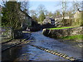
6
The ford at Butterton
The road runs along the stream bed (or is it the stream running along the road bed?) for some 70 metres
Image: © Alan Murray-Rust
Taken: 3 Jun 2007
0.09 miles
7
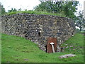
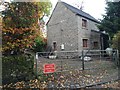
Butterton Limekiln
The village may have a nice church, a stream running down the main road and a pub with a giant peg for a sign but there is also a limekiln tucked away in a corner of a field.
Image: © Paul Glover
Taken: 25 Jul 2010
0.09 miles
8
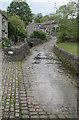
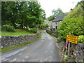
The ford at Butterton
A long ford with the stream following the road bed for some 70 metres, paved in stone throughout. The raised footway appears to double as the front garden of the house. The (handwritten) notice on the wall reads: SLOW ANIMALS CROSSING ROAD RIVER. Clearly even the locals do not know whether it is a road or a river.
Image: © Alan Murray-Rust
Taken: 3 Jun 2007
0.10 miles
10
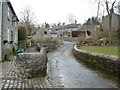
The ford at Butterton
A most attractive little village in Staffordshire.
Image: © Peter Barr
Taken: 20 Jul 2011
0.10 miles