IMAGES TAKEN NEAR TO
Thorncliffe, LEEK, ST13 7LR
Introduction
This page details the photographs taken nearby to ST13 7LR by members of the Geograph project.
The Geograph project started in 2005 with the aim of publishing, organising and preserving representative images for every square kilometre of Great Britain, Ireland and the Isle of Man.

There are currently over 7.5m images from over14,400 individuals and you can help contribute to the project by visiting https://www.geograph.org.uk
Image Map (Loading...)


Getting Data...Please wait
Leaflet Map data © OpenStreetMap
Images are licensed for reuse under creativecommons.org/licenses/by-sa/2.0
Notes
- Clicking on the map will re-center to the selected point.
- The higher the marker number, the further away the image location is from the centre of the postcode.
Image Listing (4 Images Found)
Images are licensed for reuse under creativecommons.org/licenses/by-sa/2.0
Image
Details
Distance
3
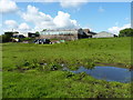
Barns and wet fields at Stile House farm
Image: © Richard Law
Taken: 19 Jun 2012
0.15 miles
4
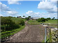
Stile House farm from the east
This good, albeit muddy, track runs east from the farm towards the hayfields running up onto Morridge, but it peters out soon after this point. The footpath then continues rather vaguely eastwards across those fields.
Image: © Richard Law
Taken: 19 Jun 2012
0.18 miles