IMAGES TAKEN NEAR TO
Ostlers Lane, LEEK, ST13 7DQ
Introduction
This page details the photographs taken nearby to Ostlers Lane, ST13 7DQ by members of the Geograph project.
The Geograph project started in 2005 with the aim of publishing, organising and preserving representative images for every square kilometre of Great Britain, Ireland and the Isle of Man.

There are currently over 7.5m images from over14,400 individuals and you can help contribute to the project by visiting https://www.geograph.org.uk
Image Map
Images are licensed for reuse under creativecommons.org/licenses/by-sa/2.0
Notes
- Clicking on the map will re-center to the selected point.
- The higher the marker number, the further away the image location is from the centre of the postcode.
Image Listing (11 Images Found)
Images are licensed for reuse under creativecommons.org/licenses/by-sa/2.0
Image
Details
Distance
2
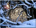
Hedgerow in winter
Taken near to Heath House Farm
Image: © Julie Montgomery
Taken: 26 Dec 2005
0.06 miles
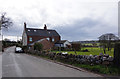
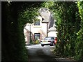
3
Ostlers Lane, Cheddleton
Residential area south of the village.
Image: © David Weston
Taken: 24 Jul 2014
0.14 miles
4
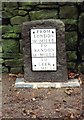
Old Milestone by the A520, Ashcombe Park, Cheddleton parish
Metal plate attached to stone post by the A520, in parish of CHEDDLETON (STAFFORDSHIRE MOORLANDS District), Cheddleton Park, by gates to Ashcombe Park, in front of stone wall, on East side of road. Sandon iron plate, erected by the Sandon, Hugbridge, Hilderstone, Bullock Smithy turnpike trust in the 19th century.
Inscription reads:-
FROM
LONDON
151 . MILES
----
TO
SANDON
15 . MILES
----
TO
LEEK
3 . MILES
Staffordshire HER.
HER Number: 53355 https://www.heritagegateway.org.uk/Gateway/Results_Single.aspx?uid=MST17121&resourceID=1010
Milestone Society National ID: ST_STLK20A.
Image: © J Higgins
Taken: 1 Jan 2004
0.19 miles
5
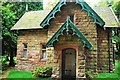
Lodge to Ashcombe Park, Cheddleton
Grade II listed building since 15 December 1986.
Image: © Stu JP
Taken: 10 Oct 2015
0.20 miles
6
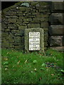
The south Cheddleton milestone - detail
This stone is a completely different style and type to all the other distance markers along this road, such as the nearby Image
Image: © Richard Law
Taken: 15 Sep 2009
0.21 miles
7
The south Cheddleton milestone in its setting
In addition to the milepost in Image, this milestone sits at the top of Cheddleton Hill, right outside the gatehouse to Ashcombe Park.
Image: © Richard Law
Taken: 15 Sep 2009
0.21 miles
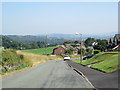
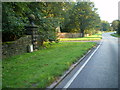
9
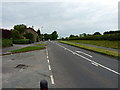
A520 near Heath House
A section of the main Cheadle to Leek road, on a relatively quiet afternoon.
Image: © Richard Law
Taken: 3 Jun 2014
0.23 miles
10
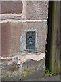
OS Flush Bracket, Scraggs Gate cottage near Heath House
An OS flush bracket affixed to one of the cottages beside the old part of the Cheadle Road; originally levelled in 1982 at 210.224m above Ordnance Datum Newlyn
Image: © Richard Law
Taken: 3 Jun 2014
0.23 miles