IMAGES TAKEN NEAR TO
Campbell Avenue, LEEK, ST13 5RP
Introduction
This page details the photographs taken nearby to Campbell Avenue, ST13 5RP by members of the Geograph project.
The Geograph project started in 2005 with the aim of publishing, organising and preserving representative images for every square kilometre of Great Britain, Ireland and the Isle of Man.

There are currently over 7.5m images from over14,400 individuals and you can help contribute to the project by visiting https://www.geograph.org.uk
Image Map
Images are licensed for reuse under creativecommons.org/licenses/by-sa/2.0
Notes
- Clicking on the map will re-center to the selected point.
- The higher the marker number, the further away the image location is from the centre of the postcode.
Image Listing (27 Images Found)
Images are licensed for reuse under creativecommons.org/licenses/by-sa/2.0
Image
Details
Distance
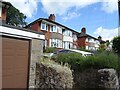
1
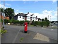
Houses on Newcastle Road, Leek
Showing position of Postbox No. ST13 709.
See Image] for postbox.
Image: © JThomas
Taken: 5 Jul 2024
0.03 miles
2
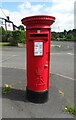
Elizabeth II postbox on Newcastle Road, Leek
Postbox No. ST13 709.
See Image] for context.
Image: © JThomas
Taken: 5 Jul 2024
0.03 miles
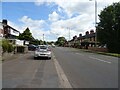
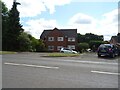
4
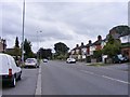
Newcastle Road
The view of the A53 in Leek, Staffordshire.
Image: © Gordon Griffiths
Taken: 14 Sep 2018
0.09 miles
7
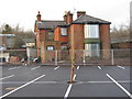
Former Public House
There seems to be a mystery surrounding this building- formerly a pub called the Churnet Valley, it has been closed for many years and has steadily been falling into ruin. Morrisons (Image) have been expanding their new car park around it, but have left the building standing for some reason. This reason could be that many local people are under the impression that there is a preservation order on it- we shall wait and see. Update: the building was demolished in February 2010, now Morrisons' can expand their car-park and make a new entrance.
Image: © Jonathan Kington
Taken: 10 Dec 2009
0.13 miles
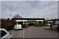
8
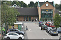
Morrisons supermarket on route of former railway
This is the view from the former railway bridge, which now serves the supermarket fuel station. The store has been built directly over the railway trackbed.
Image: © David Martin
Taken: 6 Aug 2022
0.14 miles
9
Leek Former Railway Station, Now a Morrisons Car Park
Leek had a substantial station and goods yard, but competition from road transport led to the withdrawal of services to Stoke-on-Trent in 1956 and the remaining passenger services to Uttoxeter in 1965. Freight workings continued until 1970.
The site of the station is now occupied by a Morrisons supermarket, although the road bridge is still in situ between the car park and petrol station.
https://en.wikipedia.org/wiki/Leek_railway_station
Image: © Brian Deegan
Taken: 21 Mar 2020
0.14 miles
10
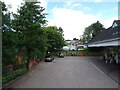
Supermarket service station, Leek
On the site of a former railway.
Image: © JThomas
Taken: 5 Jul 2024
0.15 miles