IMAGES TAKEN NEAR TO
Cornhill Cross, LEEK, ST13 5RF
Introduction
This page details the photographs taken nearby to Cornhill Cross, ST13 5RF by members of the Geograph project.
The Geograph project started in 2005 with the aim of publishing, organising and preserving representative images for every square kilometre of Great Britain, Ireland and the Isle of Man.

There are currently over 7.5m images from over14,400 individuals and you can help contribute to the project by visiting https://www.geograph.org.uk
Image Map (Loading...)


Getting Data...Please wait
Leaflet Map data © OpenStreetMap
Images are licensed for reuse under creativecommons.org/licenses/by-sa/2.0
Notes
- Clicking on the map will re-center to the selected point.
- The higher the marker number, the further away the image location is from the centre of the postcode.
Image Listing (26 Images Found)
Images are licensed for reuse under creativecommons.org/licenses/by-sa/2.0
Image
Details
Distance
1
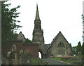
Leek Cemetery
This is the chapel at Leek Cemetery with its quite splendid spire. The wall on the left encloses a small garden of remembrance.
Image: © Neil Lewin
Taken: 25 Aug 2006
0.05 miles
2
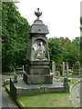
A fine memorial
Situated in Leek Cemetery, even with the damage to the base this is still a proud memorial.
Image: © Neil Lewin
Taken: 25 Aug 2006
0.05 miles
3
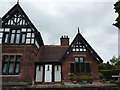
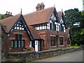
Condlyffe Almshouses, Nos 1 and 2
Each of the gable ends of these dwellings carries a text from the scriptures. The almshouses were built in 1882.
Image: © Peter Barr
Taken: 29 May 2013
0.08 miles
5
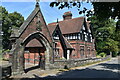
Condlyffe Almshouses - the northern end
The northern end of a row of almshouses built in 1882, and founded by Elizabeth Condlyffe, a member of a local landowning family.
Image: © Richard Law
Taken: 15 Jul 2009
0.09 miles
6
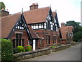
Condlyffe Almshouses - the southern end
The southern end of a row of almshouses built in 1882, and founded by Elizabeth Condlyffe, a member of a local landowning family.
Image: © Richard Law
Taken: 15 Jul 2009
0.09 miles
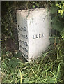
7
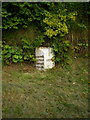
Leek milepost - detail
A milepost on the south side of Leek - gradually disappearing into the ground and the undergrowth.
Image: © Richard Law
Taken: 15 Jul 2009
0.09 miles
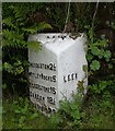
9
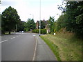
Old Milepost by the A520, Cheddleton Road, Leek
Cast iron post by the A520, in parish of LEEK (STAFFORDSHIRE MOORLANDS District), South of Leek town centre, on grass verge in front of rocks, behind fence (no access), on East side of road. Lathe iron casting, erected by the County Council in the 19th/20th century. An earlier photograph can be found here https://www.geograph.org.uk/photo/6035264.
Inscription reads:-
: CHEDDLETON 2½ / WETLEY ROCKS 5 / HILDERSTONE 15 / SANDON 18½ / STAFFORD 23 : : LEEK : : LEEK ½ :
Maker:-
: Chas. Lathe, Tipton. :
Staffordshire HER listed. HER Number: 53359 https://www.heritagegateway.org.uk/Gateway/Results_Single.aspx?uid=MST17125&resourceID=1010
Milestone Society National ID: ST_STLK23.
Image: © Ian King
Taken: 28 Jul 2021
0.10 miles
10
Old Milepost by the A520, Cheddleton Road, Leek
Cast iron post by the A520, in parish of LEEK (STAFFORDSHIRE MOORLANDS District), South of Leek town centre, on grass verge in front of rocks, behind fence (no access), on East side of road. Lathe iron casting, erected by the County Council in the 19th/20th century.
Inscription reads:-
: CHEDDLETON 2½ / WETLEY ROCKS 5 / HILDERSTONE 15 / SANDON 18½ / STAFFORD 23 : : LEEK : : LEEK ½ :
Maker:-
: Chas. Lathe, Tipton. :
Staffordshire HER listed. HER Number: 53359
https://www.heritagegateway.org.uk/Gateway/Results_Single.aspx?uid=MST17125&resourceID=1010
Milestone Society National ID: ST_STLK23.
Image: © Mike Faherty
Taken: 16 Jul 2007
0.10 miles