IMAGES TAKEN NEAR TO
The Quadrant, Town Road, STOKE-ON-TRENT, ST1 2QD
Introduction
This page details the photographs taken nearby to The Quadrant, Town Road, ST1 2QD by members of the Geograph project.
The Geograph project started in 2005 with the aim of publishing, organising and preserving representative images for every square kilometre of Great Britain, Ireland and the Isle of Man.

There are currently over 7.5m images from over14,400 individuals and you can help contribute to the project by visiting https://www.geograph.org.uk
Image Map
Images are licensed for reuse under creativecommons.org/licenses/by-sa/2.0
Notes
- Clicking on the map will re-center to the selected point.
- The higher the marker number, the further away the image location is from the centre of the postcode.
Image Listing (90 Images Found)
Images are licensed for reuse under creativecommons.org/licenses/by-sa/2.0
Image
Details
Distance
1
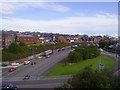
Potteries Way, Hanley
Looking from the top floor of the "Potteries Shopping Centre" car park.
Image: © Carl Farnell
Taken: 18 Jul 2005
0.03 miles
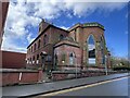
2
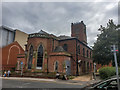
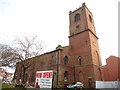
St John the Evangelist Church (disused), Hanley
The church of St. John (originally built 1737, and rebuilt 1788) is a plain brick building in debased Gothic style.
The church was closed in 1988.
http://www.thepotteries.org/church/hanley/st_john.htm
Image: © Brian Deegan
Taken: 9 Aug 2019
0.04 miles
3
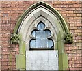
Window of St John the Evangelist, Hanley
Originally constructed in 1737 and closed in 1985 when the tower was declared unsafe, the church is Grade II* listed: the official list entry is here
https://historicengland.org.uk/listing/the-list/list-entry/1210680?section=official-list-entry
More informstion can be found on thepotteries.org website including an interesting 2007 essay 'Ragged Glory' by David Proudlove:
https://www.thepotteries.org/heritage/st_john_hanley.htm
Image: © Jonathan Hutchins
Taken: 29 Mar 2024
0.05 miles
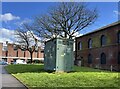
5
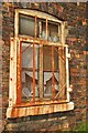
Broken Window (Airspace building)
A window with a protective cage over it. Broken glass and rusty metal.
Image: © Stu JP
Taken: 21 May 2012
0.05 miles
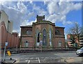
6
St John the Evangelist, Hanley
Originally constructed in 1737 and closed in 1985 when the tower was declared unsafe, the church is Grade II* listed: the official list entry is here
https://historicengland.org.uk/listing/the-list/list-entry/1210680?section=official-list-entry
More informstion can be found on thepotteries.org website including an interesting 2007 essay 'Ragged Glory' by David Proudlove:
https://www.thepotteries.org/heritage/st_john_hanley.htm
Image: © Jonathan Hutchins
Taken: 29 Mar 2024
0.05 miles
7
St John the Evangelist, Hanley
Originally constructed in 1737 and closed in 1985 when the tower was declared unsafe, the church is Grade II* listed: the official list entry is here
https://historicengland.org.uk/listing/the-list/list-entry/1210680?section=official-list-entry
More informstion can be found on thepotteries.org website including an interesting 2007 essay 'Ragged Glory' by David Proudlove:
https://www.thepotteries.org/heritage/st_john_hanley.htm
Image: © Jonathan Hutchins
Taken: 29 Mar 2024
0.05 miles
8
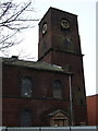
Former church of St John the Evangelist, Hanley
Photograph taken before the repair work to the tower started.
Image: © Dave Kelly
Taken: 3 Mar 2010
0.06 miles
9
Hanley, former church of St John the Evangelist
The former church has been restored and is now an Antiques Emporium.
Image: © Dave Kelly
Taken: 14 Dec 2018
0.06 miles
10
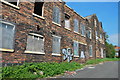
Airspace (looking NE)
Disused Airspace building at the end of Old Town Road in Hanley. Welcome to Stoke!
Image: © Stu JP
Taken: 21 May 2012
0.06 miles