IMAGES TAKEN NEAR TO
Lockwood Road, STOKE-ON-TRENT, ST10 4QU
Introduction
This page details the photographs taken nearby to Lockwood Road, ST10 4QU by members of the Geograph project.
The Geograph project started in 2005 with the aim of publishing, organising and preserving representative images for every square kilometre of Great Britain, Ireland and the Isle of Man.

There are currently over 7.5m images from over14,400 individuals and you can help contribute to the project by visiting https://www.geograph.org.uk
Image Map
Images are licensed for reuse under creativecommons.org/licenses/by-sa/2.0
Notes
- Clicking on the map will re-center to the selected point.
- The higher the marker number, the further away the image location is from the centre of the postcode.
Image Listing (3 Images Found)
Images are licensed for reuse under creativecommons.org/licenses/by-sa/2.0
Image
Details
Distance
2
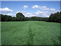
The Woodhead Tramroad
This low embankment, traced out by my footsteps across the damp grass of Gibridding Field, once carried the Woodhead Tramroad to the top of the inclined plane in Gibridding Wood.
Image: © Ian Calderwood
Taken: 15 Aug 2015
0.16 miles
3
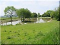
Fishing Lake behind Wood House Farm Care Home
Wood House Farm is now a large care home. This lake forms part of the landscaping of the grounds.
Image: © Mike Bardill
Taken: 7 Jun 2007
0.17 miles