IMAGES TAKEN NEAR TO
Star Road, STOKE-ON-TRENT, ST10 3DH
Introduction
This page details the photographs taken nearby to Star Road, ST10 3DH by members of the Geograph project.
The Geograph project started in 2005 with the aim of publishing, organising and preserving representative images for every square kilometre of Great Britain, Ireland and the Isle of Man.

There are currently over 7.5m images from over14,400 individuals and you can help contribute to the project by visiting https://www.geograph.org.uk
Image Map
Images are licensed for reuse under creativecommons.org/licenses/by-sa/2.0
Notes
- Clicking on the map will re-center to the selected point.
- The higher the marker number, the further away the image location is from the centre of the postcode.
Image Listing (27 Images Found)
Images are licensed for reuse under creativecommons.org/licenses/by-sa/2.0
Image
Details
Distance
1
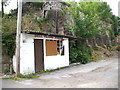
Dell Filling Station, Oakamoor, Staffordshire
Disused village filling station in Oakamoor, Staffordshire
Image: © Alf Beard
Taken: 12 Jun 2008
0.03 miles
2
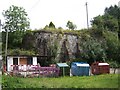
Limekilns
These lime kilns would have taken limestone from the quarries at Caldon Low, delivered via the nearby Uttoxeter Canal.
Image: © Ian Calderwood
Taken: 22 Aug 2006
0.04 miles
3
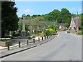
Oakamoor Village Centre
Oakamoor lies in a steep wooded valley in the Staffordshire moorlands. At one time it was served by both a canal and a railway. The canal has long since gone but the railway track bed still exists. To the south the track is now a pleasant multi-user trail to Alton. To the northwest it connects to the Churnet Valley preserved railway with the prospect that one day the line might be extended once more into Oakamoor.
Image: © Mike Bardill
Taken: 7 Jun 2007
0.07 miles
4
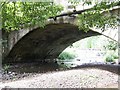
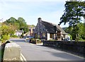
Widened Bridge over the Churnet in Oakamoor
The bridge over the River Churnet in Oakamoor was built in 1710. It was widened to turnpike standards in 1778 as part of the Blythe Marsh to Thorpe Turnpike road.
Image: © Ian Calderwood
Taken: 22 Aug 2006
0.08 miles
5
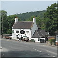
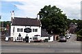
The Cricketers Arms, Oakamoor, Staffordshire
Village public house
Image: © Alf Beard
Taken: 12 Jul 2013
0.08 miles
6
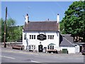
The Cricketers Arms
This was originally a canal-side building. The pub beer garden is in the bed of the former Uttoxeter Canal, next to the blocked-up arch of a canal bridge.
Image: © Ian Calderwood
Taken: 27 May 2012
0.08 miles
8
Oakamoor Village Hall
http://www.communitiestogether.org.uk/group/oakamoor-village-hall
Image: © Mike Faherty
Taken: 7 Oct 2012
0.09 miles
9
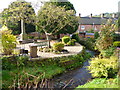
Oakamoor, Cotton Brook
Culverted, to provide a water supply for the erstwhile Caldon Canal; to the left, the village war memorial.
Image: © Mike Faherty
Taken: 7 Oct 2012
0.09 miles
10
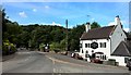
The Cricketers Arms, Oakamoor
The village cricket club was formed in 1866
Image: © Graham Hogg
Taken: 17 Aug 2015
0.10 miles