IMAGES TAKEN NEAR TO
Browning Close, STOKE-ON-TRENT, ST10 1XD
Introduction
This page details the photographs taken nearby to Browning Close, ST10 1XD by members of the Geograph project.
The Geograph project started in 2005 with the aim of publishing, organising and preserving representative images for every square kilometre of Great Britain, Ireland and the Isle of Man.

There are currently over 7.5m images from over14,400 individuals and you can help contribute to the project by visiting https://www.geograph.org.uk
Image Map
Images are licensed for reuse under creativecommons.org/licenses/by-sa/2.0
Notes
- Clicking on the map will re-center to the selected point.
- The higher the marker number, the further away the image location is from the centre of the postcode.
Image Listing (6 Images Found)
Images are licensed for reuse under creativecommons.org/licenses/by-sa/2.0
Image
Details
Distance
3
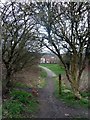
Footpath leaving Cheadle
The footpath here follows the alignment of the railway line into Cheadle which was abandoned in 1982.
Image: © Graham Hogg
Taken: 21 Mar 2012
0.16 miles
4

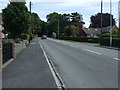
The Green
The A521 heading east through Brookhouses.
Image: © JThomas
Taken: 12 Jul 2014
0.21 miles