
IMAGES TAKEN NEAR TO
Wedgwood Road, STOKE-ON-TRENT, ST10 1LD
Introduction
This page details the photographs taken nearby to Wedgwood Road, ST10 1LD by members of the Geograph project.
The Geograph project started in 2005 with the aim of publishing, organising and preserving representative images for every square kilometre of Great Britain, Ireland and the Isle of Man.

There are currently over 7.5m images from over14,400 individuals and you can help contribute to the project by visiting https://www.geograph.org.uk
Image Map
Images are licensed for reuse under creativecommons.org/licenses/by-sa/2.0
Notes
- Clicking on the map will re-center to the selected point.
- The higher the marker number, the further away the image location is from the centre of the postcode.
Image Listing (4 Images Found)
Images are licensed for reuse under creativecommons.org/licenses/by-sa/2.0
Image
Details
Distance
1
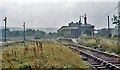
Cheadle (Staffs.) station remains
View eastward, towards the buffer-stops, ex-North Staffordshire Railway branch from Cresswell. A passenger service survived until 17/6/63 and goods trains continued until 12/5/86 - hence the rails still shining in 1983.
Image: © Ben Brooksbank
Taken: 27 Aug 1983
0.17 miles
4
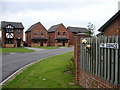
The Sidings
Cheadle, Staffordshire. At the end of Station Road and with Pullman Close off it, one does not need to be a student of old maps to guess that this is the site of Cheadle railway station. It was the terminus of a four mile line which stayed independent of the North Staffordshire Railway http://en.wikipedia.org/wiki/North_Staffordshire_Railway#Running_rights_and_other_companies
Image: © Roger W Haworth
Taken: 15 Aug 2006
0.19 miles