IMAGES TAKEN NEAR TO
Park Drive, STOKE-ON-TRENT, ST10 1JN
Introduction
This page details the photographs taken nearby to Park Drive, ST10 1JN by members of the Geograph project.
The Geograph project started in 2005 with the aim of publishing, organising and preserving representative images for every square kilometre of Great Britain, Ireland and the Isle of Man.

There are currently over 7.5m images from over14,400 individuals and you can help contribute to the project by visiting https://www.geograph.org.uk
Image Map (Loading...)


Getting Data...Please wait
Leaflet Map data © OpenStreetMap
Images are licensed for reuse under creativecommons.org/licenses/by-sa/2.0
Notes
- Clicking on the map will re-center to the selected point.
- The higher the marker number, the further away the image location is from the centre of the postcode.
Image Listing (6 Images Found)
Images are licensed for reuse under creativecommons.org/licenses/by-sa/2.0
Image
Details
Distance
2

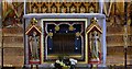
Cheadle: St. Giles' Church: Pugin's complete c13th restoration 5
Image: © Michael Garlick
Taken: 29 Apr 2016
0.23 miles
3
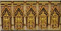
Cheadle: St. Giles' Church: Pugin's complete c13th restoration 6
Image: © Michael Garlick
Taken: 29 Apr 2016
0.23 miles
4

Cheadle: St. Giles' Church: Pugin's complete c13th restoration 9
Image: © Michael Garlick
Taken: 29 Apr 2016
0.23 miles
5
Cheadle: St. Giles' Church: Pugin's complete c13th restoration 11
Image: © Michael Garlick
Taken: 29 Apr 2016
0.23 miles
6
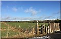
Cheadle: footpath at end of Highfield Avenue
Leading out into the fields from the end of Highfield Avenue, the footpath's designation is FP Cheadle 31.
Image: © Jonathan Hutchins
Taken: 3 Mar 2015
0.23 miles