IMAGES TAKEN NEAR TO
Silverstone Avenue, STOKE-ON-TRENT, ST10 1DD
Introduction
This page details the photographs taken nearby to Silverstone Avenue, ST10 1DD by members of the Geograph project.
The Geograph project started in 2005 with the aim of publishing, organising and preserving representative images for every square kilometre of Great Britain, Ireland and the Isle of Man.

There are currently over 7.5m images from over14,400 individuals and you can help contribute to the project by visiting https://www.geograph.org.uk
Image Map
Images are licensed for reuse under creativecommons.org/licenses/by-sa/2.0
Notes
- Clicking on the map will re-center to the selected point.
- The higher the marker number, the further away the image location is from the centre of the postcode.
Image Listing (7 Images Found)
Images are licensed for reuse under creativecommons.org/licenses/by-sa/2.0
Image
Details
Distance
1
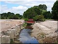
Cecilly Mills demolition and Cecilly Brook
Cecilly Mills was a silk and cotton mill and, most recently, a JCB factory. JCB relocated to a new factory elsewhere in Cheadle and the mills were demolished early in 2017. The demolition exposed Cecilly Brook, which had been culverted under one of the buildings.
Image: © Ian Calderwood
Taken: 1 Jul 2017
0.13 miles
2
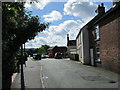
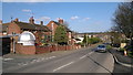
Well Street, Cheadle
Some haphazardly-placed houses, between the town centre and the more recently built housing.
Image: © David Weston
Taken: 30 Jun 2016
0.22 miles
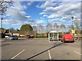
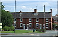
5
Ashbourne Road, Cheadle
An observatory in the garden?
Image: © Chris Morgan
Taken: 21 Mar 2012
0.24 miles
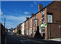
7
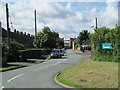
Well Street, Cheadle
A residential area. At the far end, the street meets Ashbourne Road.
Image: © David Weston
Taken: 30 Jun 2016
0.25 miles