IMAGES TAKEN NEAR TO
Southwood Gardens, LEIGH-ON-SEA, SS9 5DP
Introduction
This page details the photographs taken nearby to Southwood Gardens, SS9 5DP by members of the Geograph project.
The Geograph project started in 2005 with the aim of publishing, organising and preserving representative images for every square kilometre of Great Britain, Ireland and the Isle of Man.

There are currently over 7.5m images from over14,400 individuals and you can help contribute to the project by visiting https://www.geograph.org.uk
Image Map
Images are licensed for reuse under creativecommons.org/licenses/by-sa/2.0
Notes
- Clicking on the map will re-center to the selected point.
- The higher the marker number, the further away the image location is from the centre of the postcode.
Image Listing (10 Images Found)
Images are licensed for reuse under creativecommons.org/licenses/by-sa/2.0
Image
Details
Distance
1
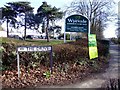
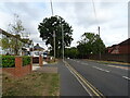
Garden centre on A1015
Too much money is spent in here!
Image: © Julieanne Savage
Taken: 1 Feb 2007
0.13 miles
3
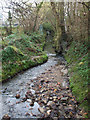
Eastwood Brook
This is the brook flowing to the south of what was the Silver Jubilee Public House, which is now Miller and Carter Steakhouse Pub Grill. Taken from the bridge in Rayleigh Downs Road.
Image: © terry joyce
Taken: 11 Feb 2011
0.19 miles
4
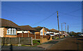
Connaught Road
The residential part of Connaught Road before it vanishes into Grove Woods en-route to the sewage works.
Image: © John Myers
Taken: 7 Dec 2007
0.21 miles
5
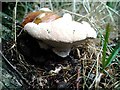
"Chicken of the Woods"
Aka. Sulphur Polypore or Laetiporus sulphureus. Old specimen at base of oak in Connaught Road, Rayleigh
Image: © John Myers
Taken: 14 Aug 2006
0.21 miles
6
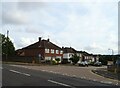
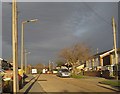
Connaught Road, Rayleigh
A road typical of the area, with no two houses quite the same and conspicuous power lines.
Image: © David Kemp
Taken: 13 Jan 2022
0.22 miles
8
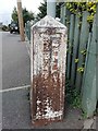
Old Boundary Marker
Municipal Boundary Marker on the pavement on the east side of Eastwood Rose, Leigh on Sea. On the current boundary of Rayleigh parish and Southend on Sea unitary authority. COUNTY BOROUGH OF / SOUTHEND-ON-SEA and RAYLEIGH URBAN / DISTRICT in vertical raised lettering on opposite sides.
Milestone Society National ID: EX_SOUS09pb
Image: © R Rothwell
Taken: 8 Sep 2020
0.23 miles
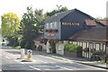
9
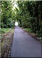
Connaught Road, Rayleigh
Byway through Grove Woods.
Image: © John Myers
Taken: 20 Aug 2007
0.23 miles