IMAGES TAKEN NEAR TO
Westleigh Avenue, LEIGH-ON-SEA, SS9 2LG
Introduction
This page details the photographs taken nearby to Westleigh Avenue, SS9 2LG by members of the Geograph project.
The Geograph project started in 2005 with the aim of publishing, organising and preserving representative images for every square kilometre of Great Britain, Ireland and the Isle of Man.

There are currently over 7.5m images from over14,400 individuals and you can help contribute to the project by visiting https://www.geograph.org.uk
Image Map
Images are licensed for reuse under creativecommons.org/licenses/by-sa/2.0
Notes
- Clicking on the map will re-center to the selected point.
- The higher the marker number, the further away the image location is from the centre of the postcode.
Image Listing (10 Images Found)
Images are licensed for reuse under creativecommons.org/licenses/by-sa/2.0
Image
Details
Distance
1
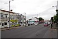
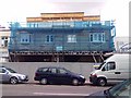
London Rd (A13)
The A13 is a ribbon of commerce that cuts through the leafy suburbs of Leigh, Chalkwell & Westcliff.
Image: © Glyn Baker
Taken: 20 May 2016
0.02 miles
3
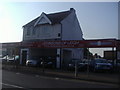
Johnsons of Leigh, car dealers, London Road
Image: © David Howard
Taken: 24 May 2012
0.03 miles
4
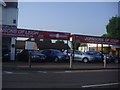
Cars outside Johnsons of Leigh, London Road
Image: © David Howard
Taken: 24 May 2012
0.04 miles
6
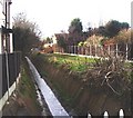
Prittle Brook, Leigh-on-Sea
Taken from Flemming Avenue looking west. Prittle Brook, a short tributary of the River Roach rising near Thundersley, forms a shallow valley through this part of Leigh.
Image: © David Kemp
Taken: 31 Dec 2005
0.08 miles
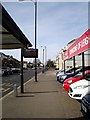
7
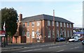
Sorting Office, Leigh-on-Sea
The Royal Mail Sorting Office, London Road, Leigh-on-Sea.
Image: © Paul Collins
Taken: 9 Aug 2007
0.09 miles
8
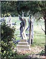
Sad Angel
This sad angel stands on duty in the Leigh-on-Sea Cemetery, London Road, Leigh-on-Sea.
Image: © Paul Collins
Taken: 9 Aug 2007
0.12 miles
9
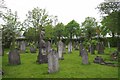
Leigh on Sea Cemetery
By the look of it this cemetery is not used for new interments.
Image: © Glyn Baker
Taken: 20 May 2016
0.12 miles
10
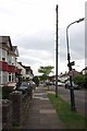
Westleigh Ave
Westleigh Ave is typical of the "between the wars" development that happened around Southend.
Image: © Glyn Baker
Taken: 20 May 2016
0.12 miles