IMAGES TAKEN NEAR TO
The Picketts, CANVEY ISLAND, SS8 9NT
Introduction
This page details the photographs taken nearby to The Picketts, SS8 9NT by members of the Geograph project.
The Geograph project started in 2005 with the aim of publishing, organising and preserving representative images for every square kilometre of Great Britain, Ireland and the Isle of Man.

There are currently over 7.5m images from over14,400 individuals and you can help contribute to the project by visiting https://www.geograph.org.uk
Image Map
Images are licensed for reuse under creativecommons.org/licenses/by-sa/2.0
Notes
- Clicking on the map will re-center to the selected point.
- The higher the marker number, the further away the image location is from the centre of the postcode.
Image Listing (17 Images Found)
Images are licensed for reuse under creativecommons.org/licenses/by-sa/2.0
Image
Details
Distance
2
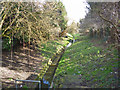
Drain, Canvey Island
One of several drains threading through and around the housing development on the island. Here it emerges from beneath the A130, the main road onto the island.
Image: © Robin Webster
Taken: 21 Feb 2015
0.06 miles

4
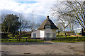
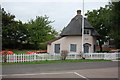
Dutch Cottage, Canvey Island
A grade II listed building, dated 1618. One of two similar cottages left on the island, from the period when a Dutch workforce were imported to secure the island from what was then frequent flooding by the sea. The date 1618 is rather odd as it predates by four or five years the start of this project. Now a museum.
Image: © Robin Webster
Taken: 21 Feb 2015
0.08 miles
5
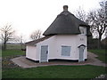
Canvey Island: The Dutch Cottage (1618)
In the early 17th Century Dutch engineers were employed to permanently reclaim Canvey Island from the sea, and they built a series of dykes, drains, embankments and sluices to manage the reclaimed land. Two of the houses that these engineers lived in have survived. This one is the earlier, dating from 1618, and is a Grade II Listed Building. The English Heritage Listed Buildings website describes it thus:-
"Cottage, now used as a museum. Dated 1618. Octagonal timber frame, plastered brick facing. Thatched circular pointed roof terminating in a circular chimney stack with moulded capping. One storey and attics. Central eyebrow dormer windows. 2 light casements with Gothic glazing, shutters to ground floor windows. Central nailed door with 5 upper and lower vertical panels. Simple pediment on brackets. Rear buttress. Left later single storey lean-to extension with red tiled roof and similar door (visible in the photo). Date 1618 over door."
The second, slightly later, cottage is here Image
As the description states the building is currently in use as a museum. Looking at old Victorian Ordnance Survey maps it appears to have survived as an outbuilding to a slightly elevated farm called Hill Hall. Both cottages were listed in 1952.
Image: © Nigel Cox
Taken: 8 Mar 2011
0.08 miles
7
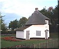
A Cool Dutch Cottage
One of the famous Canvey Island Dutch cottages read all about them at Image see the other side at Image
Image: © Glyn Baker
Taken: 5 Feb 2012
0.09 miles
8

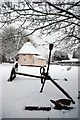
Snowy Wheel
One of several pieces of Ironmongery in the grounds of Image
Image: © Glyn Baker
Taken: 5 Feb 2012
0.10 miles
9
The Dutch Cottage, Canvey Island
The Dutch Cottage is a reminder of the 17th Century drainage of the island by Dutch engineers.
Image: © Trevor Harris
Taken: 29 Aug 2008
0.11 miles
10
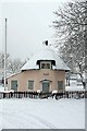
Dutch Cottage Museum, Canvey Island
Museum of island life.
Image: © John Myers
Taken: 24 Sep 2006
0.11 miles