IMAGES TAKEN NEAR TO
Letzen Road, CANVEY ISLAND, SS8 9AW
Introduction
This page details the photographs taken nearby to Letzen Road, SS8 9AW by members of the Geograph project.
The Geograph project started in 2005 with the aim of publishing, organising and preserving representative images for every square kilometre of Great Britain, Ireland and the Isle of Man.

There are currently over 7.5m images from over14,400 individuals and you can help contribute to the project by visiting https://www.geograph.org.uk
Image Map
Images are licensed for reuse under creativecommons.org/licenses/by-sa/2.0
Notes
- Clicking on the map will re-center to the selected point.
- The higher the marker number, the further away the image location is from the centre of the postcode.
Image Listing (11 Images Found)
Images are licensed for reuse under creativecommons.org/licenses/by-sa/2.0
Image
Details
Distance
1
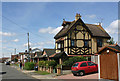
Urmond Road, Canvey Island
Another example of the variety of architectural styles found in many roads on Canvey Island.
Image: © David Kemp
Taken: 11 Aug 2018
0.06 miles
2
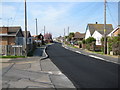
Waarden Road Canvey
Many of the roads on Canvey have Dutch names as the island was reclaimed from the sea by Dutch settlers.
Image: © Ron Galliers
Taken: 20 Mar 2009
0.06 miles
3
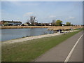
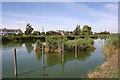
Canvey Lake
A revamped stretch of water that is home to various water birds, fish, anglers and assorted, dumped rubbish.
Image: © Ron Galliers
Taken: 17 Mar 2009
0.14 miles
4
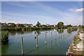
Canvey Lake, east end
Canvey Lake is said to be what remains of an old creek that once flowed through and around the five islets which originally made up what was once Cana Island. The lake is a curved and narrow stretch of brackish (slightly salty) water three-quarters of a mile in length. Over the years it has been a nature reserve.
Image: © David Kemp
Taken: 11 Aug 2018
0.14 miles
5
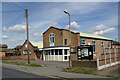
Methodist church, Waarden Road, Canvey Island
Image: © David Kemp
Taken: 11 Aug 2018
0.16 miles
6
Reed island, Canvey Lake
Canvey Lake is said to be what remains of an old creek that once flowed through and around the five islets which originally made up what was once Cana Island. The lake is a curved and narrow stretch of brackish (slightly salty) water three-quarters of a mile in length. Most of its southern side is bordered by reed beds (and houses like those in Thisselt Road seen here) and there are numerous reed islands in its midst.
Image: © David Kemp
Taken: 11 Aug 2018
0.17 miles
7

Hilton Dyke Weir, Canvey Island
Taken looking across Canvey Lake towards the houses in Thisselt Road. Hilton Dyke is a flood control channel linking the lake itself and Tewkes Creek.
Image: © David Kemp
Taken: 11 Aug 2018
0.21 miles
8
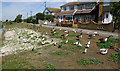
Bird feeding area, Canvey Lake
A variety of birds are to be found on and around Canvey Lake. Identifiable in this avian assemblage are Canada geese, mallards, coots, moorhens, black-headed gulls and a pigeon.
Image: © David Kemp
Taken: 11 Aug 2018
0.22 miles
9
Hilton Dyke, Canvey Island
Taken from Hilton Dyke weir. The channel seen here runs between Canvey Lake and Tewkes Creek Image
Image: © David Kemp
Taken: 11 Aug 2018
0.22 miles
10
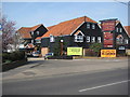
The Oysterfleet
Where Dr Feelgood started out.
Image: © Ron Galliers
Taken: 17 Mar 2009
0.23 miles