IMAGES TAKEN NEAR TO
Weel Road, CANVEY ISLAND, SS8 7NN
Introduction
This page details the photographs taken nearby to Weel Road, SS8 7NN by members of the Geograph project.
The Geograph project started in 2005 with the aim of publishing, organising and preserving representative images for every square kilometre of Great Britain, Ireland and the Isle of Man.

There are currently over 7.5m images from over14,400 individuals and you can help contribute to the project by visiting https://www.geograph.org.uk
Image Map
Images are licensed for reuse under creativecommons.org/licenses/by-sa/2.0
Notes
- Clicking on the map will re-center to the selected point.
- The higher the marker number, the further away the image location is from the centre of the postcode.
Image Listing (21 Images Found)
Images are licensed for reuse under creativecommons.org/licenses/by-sa/2.0
Image
Details
Distance
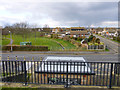
2
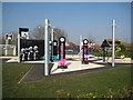
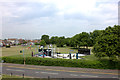
Canvey Island: Kismet Park outdoor gym
A fine sunny morning but there are no takers at this Adidas sponsored outdoor gym in Kismet Park.
Image: © Nigel Cox
Taken: 8 Mar 2011
0.13 miles
3
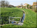
Canvey Island: Kismet Park Dyke
The photographer does not know the formal name of this dyke but it does run along the eastern side of Kismet Park and excess water is pumped out into the Thames estuary by the St Anne's Pumping Station which is behind him. Although the dyke runs in a concrete conduit, old maps show that historically, and certainly before there was any residential development, there has always been a drain along this route.
Image: © Nigel Cox
Taken: 8 Mar 2011
0.14 miles
4
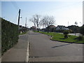
Canvey Island: Gafzelle Drive
This is the intriguingly named Gafzelle Drive viewed from the top of the sea defence wall. The Canvey Community Archive website http://canveyisland.org/page_id__1140_path__0p2p30p.aspx has several images of Gafzelle Drive taken during a freshwater flood event in 1968, some 15 years after the catastrophic seawater flood and inundation of Canvey Island in 1953.
Image: © Nigel Cox
Taken: 8 Mar 2011
0.14 miles
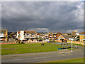
6
Hellendoorn Road, Canvey Island
Just about every direction you looked, the weather was doing something dramatic, but miraculously Canvey Island escaped.
Image: © Robin Webster
Taken: 21 Feb 2015
0.15 miles
7
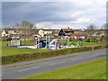
Play area, Kismet Park, Canvey Island
Viewed from the sea wall.
Image: © Robin Webster
Taken: 21 Feb 2015
0.15 miles
8
Bus stop at corner of Shellbeach Road, Canvey Island
Viewed from the sea wall.
Image: © Robin Webster
Taken: 21 Feb 2015
0.16 miles
9
St. Anne's Pumping Station, Canvey Island
One of several pumping stations and tidal sluices that handle the drainage of the island, which is below high tide level.
Image: © Robin Webster
Taken: 21 Feb 2015
0.18 miles
10
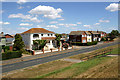
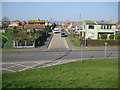
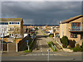
Eastern Esplanade, Canvey Island
The road leading left is Marine Avenue. Taken looking down from the seawall.
Image: © David Kemp
Taken: 28 Jul 2018
0.18 miles