IMAGES TAKEN NEAR TO
Welbeck Road, CANVEY ISLAND, SS8 0EB
Introduction
This page details the photographs taken nearby to Welbeck Road, SS8 0EB by members of the Geograph project.
The Geograph project started in 2005 with the aim of publishing, organising and preserving representative images for every square kilometre of Great Britain, Ireland and the Isle of Man.

There are currently over 7.5m images from over14,400 individuals and you can help contribute to the project by visiting https://www.geograph.org.uk
Image Map
Images are licensed for reuse under creativecommons.org/licenses/by-sa/2.0
Notes
- Clicking on the map will re-center to the selected point.
- The higher the marker number, the further away the image location is from the centre of the postcode.
Image Listing (7 Images Found)
Images are licensed for reuse under creativecommons.org/licenses/by-sa/2.0
Image
Details
Distance
1
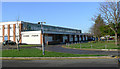
The Paddocks community centre, Canvey Island
The Paddocks is a council-run community centre at the heart of Canvey Island. Details are provided at the council's web site http://www.castlepoint.gov.uk/main.cfm?Type=2050 .
Image: © John Rostron
Taken: 25 Nov 2009
0.15 miles
3
The Paddocks Clinic, Canvey Island
This clinic, in the same grounds as the Paddocks Community Centre Image, offers several doctors' surgeries, a phlebotomy (blood sampling) clinic and a wide variety of other medical facilities, as well as a pharmacy.
The purple streak on the path leading in is an artefact due to photographing into the sun.
Image: © John Rostron
Taken: 25 Nov 2009
0.21 miles
4
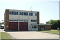
Canvey Island fire station
Canvey Island fire station, Long Road, Canvey Island, Essex
Image: © Kevin Hale
Taken: 4 Jun 2010
0.21 miles
5
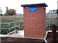
Thorney Bay Pumping Station
Keeping Canvey dry.
Image: © John Myers
Taken: 24 Sep 2006
0.23 miles
6
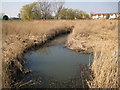
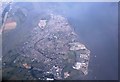
Canvey Island: Thorneycreek Fleet
Thorneycreek Fleet is one of the main natural drains on Canvey Island. This is the view from the Thorney Bay Pumping Station where excess water is pumped out through the sea defence wall into the Thames estuary. Old Victorian Ordnance Survey maps show it as Thornycreek Fleet, without the "e", with a discharge into Thorny Bay.
Image: © Nigel Cox
Taken: 8 Mar 2011
0.24 miles
7
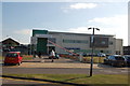
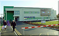
Central Canvey Primary Care Centre
Viewed from outside the Paddocks.
Image: © Trevor Harris
Taken: 14 Oct 2011
0.24 miles