IMAGES TAKEN NEAR TO
Rayleigh Road, BENFLEET, SS7 3TH
Introduction
This page details the photographs taken nearby to Rayleigh Road, SS7 3TH by members of the Geograph project.
The Geograph project started in 2005 with the aim of publishing, organising and preserving representative images for every square kilometre of Great Britain, Ireland and the Isle of Man.

There are currently over 7.5m images from over14,400 individuals and you can help contribute to the project by visiting https://www.geograph.org.uk
Image Map
Images are licensed for reuse under creativecommons.org/licenses/by-sa/2.0
Notes
- Clicking on the map will re-center to the selected point.
- The higher the marker number, the further away the image location is from the centre of the postcode.
Image Listing (14 Images Found)
Images are licensed for reuse under creativecommons.org/licenses/by-sa/2.0
Image
Details
Distance
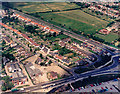
1
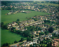
Aerial view of the Rayleigh Road with Daws Heath beyond
The Rayleigh Road (A129) runs across the lower right of the picture. The minor road at the centre is Asquith Gardens. Beyond this, the housing at the upper right lies along Daws Heath Road. Most of the pasture seen here is for horse grazing.
Image: © Edward Clack
Taken: 13 Jun 1988
0.10 miles
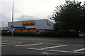
2
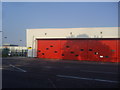
New fire station on Rayleigh Road
This has been recently completed when I arrived, and there were no visible signs nearby to indicate the usage of the building.
Image: © David Howard
Taken: 24 May 2012
0.14 miles
3
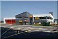
Rayleigh Weir fire station
Rayleigh Weir fire station, 500 Rayleigh Road, Stadium Trading Estate, Rayleigh Weir, Essex
Image: © Kevin Hale
Taken: 4 Jun 2010
0.15 miles
4
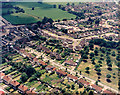
Aerial view of Kingsley Lane and Sandown Road, Thundersley
These two roads run off the Rayleigh Road (A129) just south of the Rayleigh Weir. The Rayleigh Road runs from left to right along the top of the picture. Kingsley Lane runs from the centre-left to the lower right. Sandown Road comes off the Rayleigh Road opposite the fields, runs towards then centre, then bends up towards the upper right. The parkland with scattered trees at the right is the northern end of Thundersley Common.
Image: © Edward Clack
Taken: 5 Jun 1987
0.17 miles
6
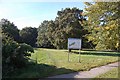
Thundersley Great Common
This is taken from Kingsley Lane at the northern end of the common.
Image: © Trevor Harris
Taken: 9 Oct 2008
0.20 miles
7
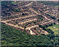
Aerial view of the ?Racecourse Estate? and Thundersley Common
The woods at the bottom of the picture are part of Thundersley Common. The housing
at the centre of the picture is known as the ‘Racecourse Estate’. The roads running from left to right, and slightly upwards beginning left-centre, are Sandown Road, Newton Park Road and Lewes Way. The road from centre-left running along the woodland edge is Cheltenham Drive. Common Lane runs from near the top centre to the mid-right.
Image: © Edward Clack
Taken: 5 Jun 1987
0.20 miles
8
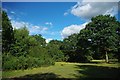
Thundersley Great Common
Thundersley Great Common see http://www.castlepoint.gov.uk/main.cfm?Type=3341 is a survivor of heathland habitat./However with the cession of grazing the common was colonised by trees many of which were cleared in 1972. In this shot you can see how the Heather is once more being out competed by birch. The landscape is now actively managed by Castlepoint Council. See also Image
Image: © Glyn Baker
Taken: 18 Sep 2010
0.21 miles
9
Aerial view of south-west of the Rayleigh Weir
The Rayleigh Weir junction is partially visible at the mid-lower right. The London Arterial Road (A127) runs from the Weir to the upper left, and the Rayleigh Road (A129) to the lower left. The road below and parallel to the A127 is Kingsley Lane. The car park to the lower right is that of Sainsbury's Supermarket. The open area bordering the Rayleigh Road now has several retail and light industrial premises.
Image: © Edward Clack
Taken: 5 Jun 1987
0.22 miles
10
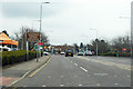
A129 Rayleigh Road
Heading towards Rayleigh, with the Rayleigh Weir roundabout ahead.
Image: © Robin Webster
Taken: 25 Mar 2018
0.22 miles