IMAGES TAKEN NEAR TO
Grandview Road, BENFLEET, SS7 3JX
Introduction
This page details the photographs taken nearby to Grandview Road, SS7 3JX by members of the Geograph project.
The Geograph project started in 2005 with the aim of publishing, organising and preserving representative images for every square kilometre of Great Britain, Ireland and the Isle of Man.

There are currently over 7.5m images from over14,400 individuals and you can help contribute to the project by visiting https://www.geograph.org.uk
Image Map
Images are licensed for reuse under creativecommons.org/licenses/by-sa/2.0
Notes
- Clicking on the map will re-center to the selected point.
- The higher the marker number, the further away the image location is from the centre of the postcode.
Image Listing (8 Images Found)
Images are licensed for reuse under creativecommons.org/licenses/by-sa/2.0
Image
Details
Distance
1
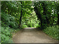
Crossfell Road, Thundersley
A public bridleway.
Image: © Robin Webster
Taken: 28 May 2017
0.09 miles
2
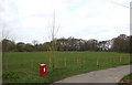
Unfenced Field
This field is along Great Burches Road, approx North West of the Water Tower.
It is not fenced and it's not clear if it's common land or belongs to someone.
Image
Image: © terry joyce
Taken: 1 Apr 2008
0.10 miles
3
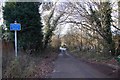
Grand View Road, Thundersley
Through the trees there is indeed a substantial view across North Benfleet, Basildon and Wickford.
Image: © Trevor Harris
Taken: 11 Jan 2009
0.12 miles
4
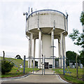
Water tower, Thundersley
A covered reservoir is to the left.
Image: © Robin Webster
Taken: 28 May 2017
0.14 miles
5
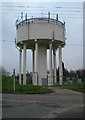
Water Tower near Little Common, Thundersley
To the left of this water tower there is a large square embankment that probably covers an underground reservoir. The photo was taken looking across Great Burches Rd.
Image: © Glyn Baker
Taken: 15 Jan 2006
0.15 miles
6
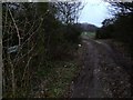
The End of Windermere Rd
This dirt track glories in the name of Windermere Rd! (the sign can be seen in the bushes to the left). There is a bridleway that passes from left to right in front of the gate.
Image: © Glyn Baker
Taken: 15 Jan 2006
0.18 miles
7
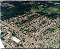
Aerial view of the Church Road - Hart Road junction, Thundersley
Church Road runs from centre-left to the lower centre. From the mini-roundabout, it continues as Hart Road to the lower right. The other road leading from the mini-roundabout to the bottom is Kenneth Road. The roads from the Church/Hart Road leading upper right are (from the left) Grasmere road, Borrowdale Road (with Borrowdale Close leading from it) and Raymonds Drive. The long white-roofed building in the lower right is the postal sorting office. The building to the right of this, at the Kenneth Road - Church Road junction is a clinic. The white triangle at the lower left is the aircraft wing.
Image: © Edward Clack
Taken: 1 Jul 1987
0.20 miles
8
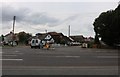
Common Approach at the junction of Hart Road
Image: © David Howard
Taken: 26 Jul 2020
0.25 miles