IMAGES TAKEN NEAR TO
Western Road, BENFLEET, SS7 2TL
Introduction
This page details the photographs taken nearby to Western Road, SS7 2TL by members of the Geograph project.
The Geograph project started in 2005 with the aim of publishing, organising and preserving representative images for every square kilometre of Great Britain, Ireland and the Isle of Man.

There are currently over 7.5m images from over14,400 individuals and you can help contribute to the project by visiting https://www.geograph.org.uk
Image Map
Images are licensed for reuse under creativecommons.org/licenses/by-sa/2.0
Notes
- Clicking on the map will re-center to the selected point.
- The higher the marker number, the further away the image location is from the centre of the postcode.
Image Listing (16 Images Found)
Images are licensed for reuse under creativecommons.org/licenses/by-sa/2.0
Image
Details
Distance
1
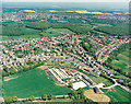
Aerial view of Daws Heath estate and the woods beyond
This photo shows virtually all of Daws Heath. Daws Heath Road runs along the upper left of the estate, then turns a sharp right just around the end of the meadows and runs south (downwards). The other main limb of the triangle is Western Road. The buildings in the lower centre are those of Solby Wood Farm.
Beyond the estate, the woods are (from left to right) Starvelarks Wood, Wyburns Wood which merges into Tile Wood, Pound Wood. Starvelarks Wood and Wyburns wood, together with the adjacent meadows are now part of the Little Haven Nature Reserve, managed by the Essex Wildlife Trust http://www.essexwt.org.uk/ , with the land being owned by the Little Havens Children's Hospice http://www.littlehavens.org.uk/. Pound Wood is owned and managed by the Essex Wildlife Trust, but Tile Wood is currently the subject of an appeal by the Essex Wildlife Trust to purchase the freehold.
Image: © Edward Clack
Taken: 8 May 1987
0.09 miles
4
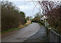
Old Daws Heath Road
This section of Daws Heath Road is now a no through road. It is parallel to the current Daws Heath Road.
Image: © terry joyce
Taken: 25 Jan 2011
0.18 miles
5
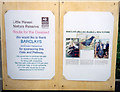
Sign for easy-access path at Little Haven nature reserve, Benfleet
The management of the Little Haven reserve aims to encourage easy access to the reserve. The reserve surrounds the Little Havens Children's Hospice http://www.littlehavens.org.uk/ who provide care for disabled children. An easy-access path provides a facility for these children as well as others. This notice marks the opening of the first stage of this easy-access path. Since then (1999) the path has been extended to many parts of the reserve.
The Little Haven nature reserve land is owned by Havens Christian Hospice http://www.havenshospices.org.uk/ and is managed by the Essex Wildlife Trust http://www.essexwt.org.uk/ .
Image: © John Rostron
Taken: 15 May 1999
0.19 miles
6
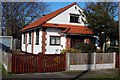
Moorcroft Hall, Daws Heath
This little gospel hall in Moorcroft Avenue now has a "For Sale" sign up outside it, so presumably will be having no more prayer meetings or Sunday Schools.
Image: © Trevor Harris
Taken: 7 Feb 2009
0.20 miles
7
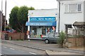
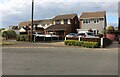
Ann's Mini-Market, Daws Heath
Ann's store is the heart of Daws Heath.
Image: © Trevor Harris
Taken: 29 Jul 2008
0.21 miles
8

Cotoneaster horizontalis and spider's web
Image: © Trevor Harris
Taken: 14 Nov 2022
0.22 miles
9
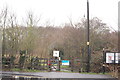
Little Haven Nature Reserve
The entrance on Daws Heath Road on a wet Christmas Day.
Image: © Trevor Harris
Taken: 25 Dec 2012
0.22 miles
10
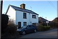
Haresland Cottages, Daws Heath
The wooden nameplate on this pair of cottages in Bramble Road reads "Haresland Cottages 1867".
Image: © Trevor Harris
Taken: 7 Feb 2009
0.23 miles