Aerial view of Daws Heath estate and the woods beyond
Introduction
The photograph on this page of Aerial view of Daws Heath estate and the woods beyond by Edward Clack as part of the Geograph project.
The Geograph project started in 2005 with the aim of publishing, organising and preserving representative images for every square kilometre of Great Britain, Ireland and the Isle of Man.

There are currently over 7.5m images from over 14,400 individuals and you can help contribute to the project by visiting https://www.geograph.org.uk
Aerial view of Daws Heath estate and the woods beyond
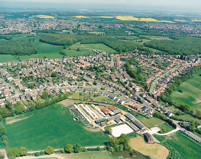
Image: © Edward Clack Taken: 8 May 1987
This photo shows virtually all of Daws Heath. Daws Heath Road runs along the upper left of the estate, then turns a sharp right just around the end of the meadows and runs south (downwards). The other main limb of the triangle is Western Road. The buildings in the lower centre are those of Solby Wood Farm. Beyond the estate, the woods are (from left to right) Starvelarks Wood, Wyburns Wood which merges into Tile Wood, Pound Wood. Starvelarks Wood and Wyburns wood, together with the adjacent meadows are now part of the Little Haven Nature Reserve, managed by the Essex Wildlife Trust http://www.essexwt.org.uk/ , with the land being owned by the Little Havens Children's Hospice http://www.littlehavens.org.uk/. Pound Wood is owned and managed by the Essex Wildlife Trust, but Tile Wood is currently the subject of an appeal by the Essex Wildlife Trust to purchase the freehold.
Images are licensed for reuse under creativecommons.org/licenses/by-sa/2.0
Image Location
Latitude
51.567519
Longitude
0.612926