IMAGES TAKEN NEAR TO
Scrub Lane, BENFLEET, SS7 2JP
Introduction
This page details the photographs taken nearby to Scrub Lane, SS7 2JP by members of the Geograph project.
The Geograph project started in 2005 with the aim of publishing, organising and preserving representative images for every square kilometre of Great Britain, Ireland and the Isle of Man.

There are currently over 7.5m images from over14,400 individuals and you can help contribute to the project by visiting https://www.geograph.org.uk
Image Map
Images are licensed for reuse under creativecommons.org/licenses/by-sa/2.0
Notes
- Clicking on the map will re-center to the selected point.
- The higher the marker number, the further away the image location is from the centre of the postcode.
Image Listing (8 Images Found)
Images are licensed for reuse under creativecommons.org/licenses/by-sa/2.0
Image
Details
Distance
1
Aerial view of Scrub Lane and Belfairs Nature Reserve
Belfairs Nature Reserve occupies most of the upper right of the picture. Scrub lane runs from the upper left corner to the bottom centre.
Image: © Edward Clack
Taken: 8 May 1987
0.12 miles
2
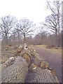
Felled Oaks
Significant clearance including these oak standards in S.W of wood.
Image: © John Myers
Taken: 8 Feb 2004
0.17 miles
3
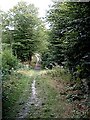
Valley track - Hadleigh Great Wood
Track running north-south through wood across the valley of a small tributary of Prittle Brook.
Image: © John Myers
Taken: 19 Aug 2006
0.20 miles
4
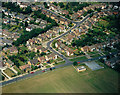
Aerial view of Scrub Lane and Greenacres, Hadleigh
Scrub Lane runs from the lower left to the mid-right. Greenacres runs from half-way along this upwards and then to the right. The playing fields in the foreground are of Hadleigh Infants School.
Image: © Edward Clack
Taken: 13 Jun 1988
0.21 miles
5
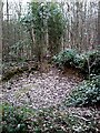
Hadleigh Gt. Wood - The Bomb Crater
Souvenir d'Adolf Hitler c.1942. After the Luftwaffe had done all the spade-work a small stream was diverted to form a pond and some bamboos, rhododendrons and a few pine trees planted to make a somewhat incongruous oriental garden in the middle of the wood. Now dry and neglected some of the original planting remains. Not on any path but the pines, the only group in the wood, serve as a guide.
Image: © John Myers
Taken: 8 Feb 2004
0.23 miles
6
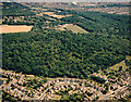
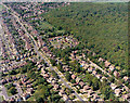
Aerial view of Hadleigh Great Wood (Belfairs Nature reserve)
The main block of woodland here is the western portion of Hadleigh Great Wood, lying within Castle Point. The bulk of the wood lies within the Southend borough.The road across the bottom right is Scrub Lane. The road curving just below the wood is Greenacres.
Image: © Edward Clack
Taken: 21 Jun 1987
0.23 miles
7
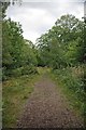
A Great Wood Path
A well maintained path through Hadleigh Great Wood http://www.visitsouthend.co.uk/Leigh-on-Sea-Belfairs-Park-and-Nature-Reserve/details/?dms=13&nearby=1&GroupId=2&venue=0670186
Image: © Glyn Baker
Taken: 28 Aug 2011
0.23 miles
8
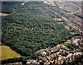
Aerial view of Belfairs Nature Reserve, Hadleigh
Belfairs Nature reserve occupies much of the centre and top left of the picture. Scrub Lane runs across the upper right corner, with Shepherds Walk and Shepherds Close in the foreground.
Image: © Edward Clack
Taken: 21 Jun 1989
0.23 miles