IMAGES TAKEN NEAR TO
Bilton Road, BENFLEET, SS7 2HQ
Introduction
This page details the photographs taken nearby to Bilton Road, SS7 2HQ by members of the Geograph project.
The Geograph project started in 2005 with the aim of publishing, organising and preserving representative images for every square kilometre of Great Britain, Ireland and the Isle of Man.

There are currently over 7.5m images from over14,400 individuals and you can help contribute to the project by visiting https://www.geograph.org.uk
Image Map
Images are licensed for reuse under creativecommons.org/licenses/by-sa/2.0
Notes
- Clicking on the map will re-center to the selected point.
- The higher the marker number, the further away the image location is from the centre of the postcode.
Image Listing (12 Images Found)
Images are licensed for reuse under creativecommons.org/licenses/by-sa/2.0
Image
Details
Distance
1
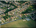
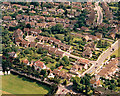
Aerial view of Scrub Lane and Greenacres, Hadleigh
Scrub Lane runs from the lower left to the mid-right. Greenacres runs from half-way along this upwards and then to the right. The playing fields in the foreground are of Hadleigh Infants School.
Image: © Edward Clack
Taken: 13 Jun 1988
0.15 miles
2
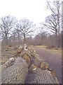
Felled Oaks
Significant clearance including these oak standards in S.W of wood.
Image: © John Myers
Taken: 8 Feb 2004
0.19 miles
4
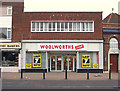
'Woolies' final week !
The final week for WOOLWORTHS in Hadleigh, Essex. Taken on 1st Jan 2009, and a sad sight it is too. I dread to think what will happen to this site now - probably be converted to retirement flats!
Image: © gary faux
Taken: 1 Jan 2009
0.23 miles
5
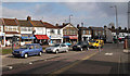
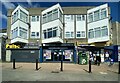
Shops at Hadleigh
These shops are on the northern side of the London Road (A13) just to the east of where splits either side of Hadleigh Church Image
Image: © John Rostron
Taken: 19 Feb 2010
0.23 miles
6
Aerial view of Scrub Lane and Rectory Road, Hadleigh
Scrub Lane runs across the lower right of the picture. Rectory Road runs across the lower left. At the junction of these (bottom-centre) there are traffic lights. The green area at the bottom left is the southern part of the John Burrows Recreation Ground.
Image: © Edward Clack
Taken: 27 Jun 1987
0.24 miles
7
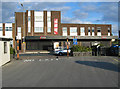
Rectory Road, Hadleigh
A branch and the head office of the Choice chain of discount stores, seen from the free car park at the head of Rectory Road.
Image: © John Allan
Taken: 16 Sep 2009
0.24 miles
8
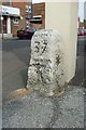
Old Milestone by the A13, London Road, Hadleigh parish
Carved stone post by the A13, in parish of HADLEIGH (CASTLE POINT District), at junction with Meadow Road, by wall in pavement, on North side of road. Erected by the Rochford Hundred (Div of Essex First Dist) turnpike trust in the 19th century.
Inscription reads:-
LONDON
37
SOUTHEND
1
Grade II listed.
List Entry Number: 1263835 https://historicengland.org.uk/listing/the-list/list-entry/1263835
Milestone Society National ID: EX_RYLE37.
Image: © JV Nicholls
Taken: Unknown
0.24 miles
9
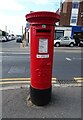
George V postbox on London Road, Hadleigh
Postbox No. SS7 216.
Image: © JThomas
Taken: 23 Aug 2022
0.24 miles
10
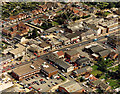
Aerial view of east Hadleigh, London Road
This shows the London Road east of the Hadleigh main centre. There are a number of shops, offices and light industry along this stretch.
Image: © Edward Clack
Taken: 11 Sep 1987
0.25 miles