
IMAGES TAKEN NEAR TO
Solby Wood Place, BENFLEET, SS7 2FS
Introduction
This page details the photographs taken nearby to Solby Wood Place, SS7 2FS by members of the Geograph project.
The Geograph project started in 2005 with the aim of publishing, organising and preserving representative images for every square kilometre of Great Britain, Ireland and the Isle of Man.

There are currently over 7.5m images from over14,400 individuals and you can help contribute to the project by visiting https://www.geograph.org.uk
Image Map
Images are licensed for reuse under creativecommons.org/licenses/by-sa/2.0
Notes
- Clicking on the map will re-center to the selected point.
- The higher the marker number, the further away the image location is from the centre of the postcode.
Image Listing (14 Images Found)
Images are licensed for reuse under creativecommons.org/licenses/by-sa/2.0
Image
Details
Distance
1
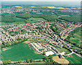
Aerial view of Daws Heath estate and the woods beyond
This photo shows virtually all of Daws Heath. Daws Heath Road runs along the upper left of the estate, then turns a sharp right just around the end of the meadows and runs south (downwards). The other main limb of the triangle is Western Road. The buildings in the lower centre are those of Solby Wood Farm.
Beyond the estate, the woods are (from left to right) Starvelarks Wood, Wyburns Wood which merges into Tile Wood, Pound Wood. Starvelarks Wood and Wyburns wood, together with the adjacent meadows are now part of the Little Haven Nature Reserve, managed by the Essex Wildlife Trust http://www.essexwt.org.uk/ , with the land being owned by the Little Havens Children's Hospice http://www.littlehavens.org.uk/. Pound Wood is owned and managed by the Essex Wildlife Trust, but Tile Wood is currently the subject of an appeal by the Essex Wildlife Trust to purchase the freehold.
Image: © Edward Clack
Taken: 8 May 1987
0.13 miles
2
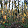
Valerie Wells Wood (Cottage Plantation), Daws Heath
This woodland, formerly known as Cottage Plantation, was bought by Essex Wildlife Trust in 2013. http://www.wildessex.net/sites/Valerie%20Wells%20Wood.htm
Image: © Roger Jones
Taken: 13 Dec 2014
0.17 miles
3
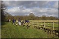
Living Landscape
Here Essex Wildlife Trust http://www.essexwt.org.uk/ Staff, volunteers and some team building workers from a corporate sponsor, were Image This is part of a Living Landscapes project http://www.essexwt.org.uk/living_landscapes/. With the cooperation of local landowners the Trust is planting hedgerows to act as wildlife corridors between the remaining fragments of woodland in the area. Today the willing workers planted in excess of 1400 saplings of Hawthorn, Blackthorn, Dogwood, Hazel and Dog Rose.
Eventually Image, Image, Image,Image and Image will all become linked with green veins to promote biodiversity.
Image: © Glyn Baker
Taken: 30 Jan 2013
0.19 miles
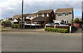
6
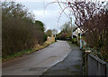
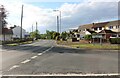
Old Daws Heath Road
This section of Daws Heath Road is now a no through road. It is parallel to the current Daws Heath Road.
Image: © terry joyce
Taken: 25 Jan 2011
0.20 miles
7

Former lane to Rag Wood
Looking south along the line of this sunken, now impassable lane. Rag Wood is a private wood between West Wood (managed by Castle Point council) and Valerie Wells Wood (formerly Cottage Plantation) now an Essex Wildlife Reserve.
Image: © Trevor Harris
Taken: 6 Feb 2021
0.21 miles
8
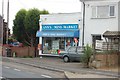
Ann's Mini-Market, Daws Heath
Ann's store is the heart of Daws Heath.
Image: © Trevor Harris
Taken: 29 Jul 2008
0.21 miles
9
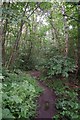
Cottage Plantation
Since being acquired by Essex Wildlife Trust http://www.essexwt.org.uk/ Cottage Plantation is to be known as Image in honour of the late Valerie Wells whose family were generous enough to gift the purchase price to The Trust. To learn more visit http://www.essexwt.org.uk/news/cottage-plantation
Image: © Glyn Baker
Taken: 5 Jul 2014
0.22 miles
10

Cotoneaster horizontalis and spider's web
Image: © Trevor Harris
Taken: 14 Nov 2022
0.22 miles