IMAGES TAKEN NEAR TO
Kiln Road, BENFLEET, SS7 1RR
Introduction
This page details the photographs taken nearby to Kiln Road, SS7 1RR by members of the Geograph project.
The Geograph project started in 2005 with the aim of publishing, organising and preserving representative images for every square kilometre of Great Britain, Ireland and the Isle of Man.

There are currently over 7.5m images from over14,400 individuals and you can help contribute to the project by visiting https://www.geograph.org.uk
Image Map
Images are licensed for reuse under creativecommons.org/licenses/by-sa/2.0
Notes
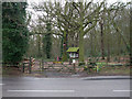
- Clicking on the map will re-center to the selected point.
- The higher the marker number, the further away the image location is from the centre of the postcode.
Image Listing (13 Images Found)
Images are licensed for reuse under creativecommons.org/licenses/by-sa/2.0
Image
Details
Distance
2
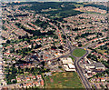
Aerial view of Kiln Road and Shipwrights Drive junction, Thundersley
Kiln Road runs across the bottom, with Shipwrights Drive joining it at the right. The land to the right, above the white house were then (1987) a nursery. This land, and the green area in the centre, is currently the subject of a planning application for 150 new houses. This, unsurprisingly, has been the subject of considerable local opposition.
Image: © Edward Clack
Taken: 3 Aug 1987
0.15 miles
3
Aerial photo of Victoria House Corner, Hadleigh, close view
This is a closer view of the Hadleigh Roundabout seen in Image Below right of the roundabout is Hadleigh Bus Garage. Below right is the Magnet showrooms for fitted kitchens. Above right is a parade of shops and restaurants. The patched green in the bottom centre-left are allotments.
Image: © Edward Clack
Taken: 3 Aug 1987
0.21 miles
4
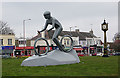
The Cyclist Statue at Hadleigh Roundabout
Castle Point District and Essex County Council were keen to exploit the Olympic Cycling Event at Hadleigh Farm in 2012. This statue is one of their commemorations. The statue was not without its critics, but when the locals were consulted about leaving it where it was or moving it to the Olympic Legacy Site, 73% voted to keep it where it was http://www.essex.gov.uk/News/Pages/THE-RESULTS-ARE-IN-%E2%80%93-MOUNTAIN-BIKE-STATUE-TO-REMAIN-ON-ROUNDABOUT.aspx .
Image: © John Rostron
Taken: 13 Apr 2013
0.23 miles
6
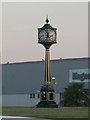
Victoria House Corner Clock Tower
Clock Tower that 'adorns' the centre of the roundabout at Victoria House Corner, Hadleigh.
Image: © Paul Collins
Taken: 31 Jul 2007
0.23 miles
7
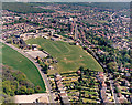
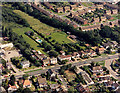
Aerial view of King John School, Benfleet, wide view
King John school is one of three large comprehensive schools in Benfleet. It lies between Shipwright's Drive (running across the lower left) and Benfleet Road (running right of centre). At the bottom left, the building partly visible is the Holywood Restaurant. The wood at the top left is West Wood, and that at the top right is Belfairs Wood.
Image: © Edward Clack
Taken: 8 May 1987
0.23 miles
8
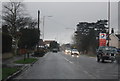
A129 Rayleigh Road
Heading towards Rayleigh.
Image: © Robin Webster
Taken: 25 Mar 2018
0.23 miles
9
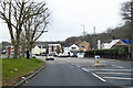
West Wood entrance
This is one of the entrances to West Wood. It is owned by Castle Point Borough Council and managed by Castle Point Wildlife Group
The road is the A129 Rayleigh Road.
http://www.castlepointwildlifegroup.co.uk
Image: © terry joyce
Taken: 25 Jan 2011
0.23 miles
10
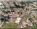
Aerial photo of Victoria House Corner, Hadleigh, wide view
Victoria House Corner is a large roundabout where The A13 (London Road), running east to west (bottom to top) is joined by the A129 (Rayleigh Road) from the north (right). The road from the roundabout to the left is the B1014 (Benfleet Road). The patched green in the bottom centre are allotments. In the top centre are wooded and open areas. Image is a closer view of the roundabout.
Image: © Edward Clack
Taken: 3 Aug 1987
0.24 miles