
IMAGES TAKEN NEAR TO
Tippersfield, BENFLEET, SS7 1JD
Introduction
This page details the photographs taken nearby to Tippersfield, SS7 1JD by members of the Geograph project.
The Geograph project started in 2005 with the aim of publishing, organising and preserving representative images for every square kilometre of Great Britain, Ireland and the Isle of Man.

There are currently over 7.5m images from over14,400 individuals and you can help contribute to the project by visiting https://www.geograph.org.uk
Image Map
Images are licensed for reuse under creativecommons.org/licenses/by-sa/2.0
Notes
- Clicking on the map will re-center to the selected point.
- The higher the marker number, the further away the image location is from the centre of the postcode.
Image Listing (11 Images Found)
Images are licensed for reuse under creativecommons.org/licenses/by-sa/2.0
Image
Details
Distance
1
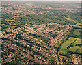
Aerial photo of Thundersley Glen and Boyce Hill golf course
Thundersley Park Road leads from right of bottom centre, curving to the left. Underhill Road leads off this right of centre. These two enclose an estate of new houses. Above this the woodland is Thundersley Glen. To the right, below centre, the light green area is part of Boyce Hill golf course.
Image: © Edward Clack
Taken: 17 Jun 1987
0.06 miles
2
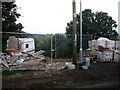
House on a Hill
It looks like someone has gained planning permission to build a house in a quite idyllic spot with a view down the hill over Thundersley Glen. The dirt track come bridleway is actually called Mount Rd.
Image: © Glyn Baker
Taken: 15 Oct 2005
0.07 miles
3
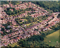
Aerial view of Underhill Road estate, South Benfleet
This is a closer view of the new estate seen in Image Underhill Road runs from the lower left towards the upper right. Thundersley Glen is to the top right, and Boyce Hill golf course to the bottom right.
Image: © Edward Clack
Taken: 17 Jun 1987
0.13 miles
4

Picnic Spot in Thundersley Glen
An open area in Thundersley Glen see http://www.castlepoint.gov.uk/main.cfm?Type=3339 for more info
Image: © Glyn Baker
Taken: 1 Jan 2010
0.16 miles
5
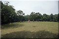
Amenity grassland within Thundersley Glen
Thundersley Glen comprises a mix of rough and amenity grassland, scrub and well-established woodland, plus the odd pond. Lying in the centre of the Benfleet built-up area, it is extensively used by dog-walkers. The person in this picture did have a dog somewhere. Here the woodland opens out to a stretch of amenity grassland.
Image: © John Rostron
Taken: Unknown
0.17 miles
6
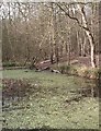
Pond - Thundersley Glen
Pond in the northern, wooded area of Thundersley Glen. The woodland is now sadly degraded but is a westerly remnant of the former ancient Jervis Wood.
Image: © John Myers
Taken: 4 Feb 2007
0.17 miles
7
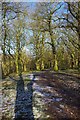
Path Through Thundersley Glen
Thundersley Glen is part of Thundersley Woods Managed by Castlepoint Council see http://www.castlepoint.gov.uk/main.cfm?Type=3339
Image: © Glyn Baker
Taken: 1 Jan 2010
0.18 miles
8
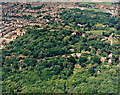
Aerial view of woodland west of Thundersley Glen, Benfleet
This shows the woodland either side of Mount Road, an unmade road south of the A13 or London Road (which lies just off the photo, to the right). Much of the woodland in the centre of the photo is managed as a private nature reserve. These woodlands lie on higher ground, which slopes towards the lower ground to the top of the photo.
Image: © Edward Clack
Taken: Unknown
0.21 miles
9
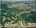
Aerial view of Coombe Wood and Thundersley Glen
The London Road (A13) runs left to right across the image. Coombe Wood lies just above this at the left and Thundersley Glen below it on the right. Hill Road runs from mid-centre bottom up towards the centre. Thundersley Park Road runs from left of centre-bottom up and curves round to join Hill Road. These two roads are unmade at the centre of the image (though they are mad at the bottom). Underhill Road runs parallel to the bottom at the right. Thundersley proper occupies much of the upper right.
Image: © Edward Clack
Taken: 1 Jul 1987
0.22 miles
10
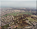
Aerial view of Boyce Hill golf course and South Benfleet
Boyce Hill golf course is the green swathe across the centre of the photo, occupying the centre of South Benfleet. The woodland above it is Thundersley Glen (also seen in Image). The sloping ground to the lower right borders onto Essex Way. We used to live in the small road at the bottom right, Norwood Drive, and the first winter after we moved there, this hillside was snow covered and used by skiers and tobogganers.
Image: © Edward Clack
Taken: 29 Mar 1990
0.22 miles