IMAGES TAKEN NEAR TO
Catherine Road, BENFLEET, SS7 1HY
Introduction
This page details the photographs taken nearby to Catherine Road, SS7 1HY by members of the Geograph project.
The Geograph project started in 2005 with the aim of publishing, organising and preserving representative images for every square kilometre of Great Britain, Ireland and the Isle of Man.

There are currently over 7.5m images from over14,400 individuals and you can help contribute to the project by visiting https://www.geograph.org.uk
Image Map
Images are licensed for reuse under creativecommons.org/licenses/by-sa/2.0
Notes
- Clicking on the map will re-center to the selected point.
- The higher the marker number, the further away the image location is from the centre of the postcode.
Image Listing (5 Images Found)
Images are licensed for reuse under creativecommons.org/licenses/by-sa/2.0
Image
Details
Distance
1
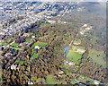
Aerial view of plotland south of London Road, Benfleet
Most of Benfleet's plotlands are well to the north of here. There is, however, a patch of plotland in central Benfleet. Like that further north, much of the open land here is used for horse grazing. The road running across the upper half is the A13 (London Road). The road running to the top from the centre of this is Rhoda Road North. Like many roads in this area, part of this is unmade. The woodland at the upper right is Coombe Wood. Part of this is secondary, but much has the characteristics of ancient woodland. The London Road alongside the wood begins a rise upwards from the London Clay flatlands to the left up to the Claygate and Bagshot Beds to the right of the photo. This stretch is known as the Bread and Cheese Hill (see Image, here Coombe Wood is on the right).
Image: © Edward Clack
Taken: 16 Oct 1987
0.08 miles
2
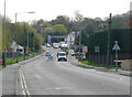
The Bread and Cheese Hill on the A13
This is the same viewpoint as Image, but taken some eighteen months later. During this time there have been extensive roadworks along the A13 with some widening. The pavements have been considerably improved, but the road surface has not. Popular opinion is that this is all to do with the Mountain Biking event for the 2012 Olympics. Road access to this site, in the Hadleigh Castle Country Park, would have to pass along here.
Image: © John Rostron
Taken: 3 Apr 2011
0.20 miles
3
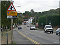
The Bread and Cheese Hill on the A13, Benfleet
This is just the lower slopes of the hill. Just beyond the bend at the top it steepens considerably to the Hadleigh plateau. The clearway facilitates the slow-moving vehicles on the hill. There is another photo of this hill at Image around eighteen months later, following roadworks.
Image: © John Rostron
Taken: 30 Sep 2009
0.24 miles